


One of the best-kept secrets about the property/casualty insurance industry is a member-centric organization that manages the largest aerial imagery program in the world.
Executive Summary
“Insurance touches everything, and everything that insurance touches has a location.” Ryan Bank, the managing director of the Geospatial Insurance Consortium, explains the history and the business model of the GIC, a member-centric organization that gives insurers aerial views of every location they need to analyze at costs they can afford.Watch related videos: “The World’s Largest Aerial Imagery Program—Managed by Insurers” and “A Top-Down View of Insurance Risk: Unlocking the Benefits of Geospatial Technology” on the Carrier Management channel of InsuranceJournal.TV
Photos supplied by GIC and Vexcel
That’s right. The world’s largest high-resolution aerial imagery program in existence isn’t something that was developed by Google or Microsoft. It was created by insurers and reinsurers, who also pay to keep a fleet of fixed-wing aircraft equipped with special cameras flying over every square inch of the continental U.S., most of Canada, Puerto Rico, all of Western Europe, the UK, Scandinavia, Australia and New Zealand.
“And we just announced our expansion of the GIC consortium into Japan as well,” Ryan Bank, the consortium’s managing director, reported recently.
Even with more than a hundred manned planes flying through the clouds over the U.S. alone, the Geospatial Insurance Consortium (GIC) was an under-the-radar organization to Carrier Management until Guest Editor Mike Fitzgerald interviewed Bank in October.
The GIC, conceived by the National Insurance Crime Bureau, is a partnership between NICB and Vexcel, a provider of camera sensors and image processing technology. Vexcel’s team and technology developed Microsoft’s Bing Maps, Bank said, going on to explain the nonprofit cost-sharing model that makes the GIC possible to Fitzgerald.
“There is not an insurer on the planet who can afford to do this themselves,” Bank said. Microsoft and Google are the only two companies that were able to do this in the past, he said. “It is hundreds of millions of dollars…It is massive.”
He explained, “The way that we’ve been able to make the model work is we stripped all profit motive out of it. So, this is done at pass-through costs. We divide it proportionately by all of the participating carrier members, based on how much premium they write in any given territory. And we did a unique partnership with Vexcel where they also contractually committed to providing the imagery through to us at that pass-through cost.” In other words, “they’re turning around and getting some subsidization from other industries on their commercial model. We as the insurance industry are the beneficiaries of that.”
“We then get all of the data that they fly to our spec, to our direction, but divided then at cost and proportionately across the industry.”
According to Bank, “It’s the largest [aerial capture] program in the world, including Microsoft and Google. And we’ve been able to divide that so that every carrier can afford it.”
After Bank’s conversation with Fitzgerald, the GIC announced a new update to the business model in late October that will make access to imagery captured by the Vexcel equipment even more affordable for some carriers. Marketing Director Kris Wagner said insurers can now opt to participate in a “no-risk transaction program”—a pay-per-use model that lets GIC members elect to pay only for images they use, but never pay more than their assessed market share based on the premium calculation that Bank described. (Under the existing model, the market share-based cost is the member cost, assessed on a quarterly basis.)
While some carriers are innovating fast, others want to start slowly with geospatial information, Wagner noted, giving the example of a carrier that could pay for one staffer to access 1,000 images in the month of July for a specific region under the no-risk program. If the carrier started ramping up to use more imagery across more divisions over time, it would continue to pay per-image costs up until the aggregate total reached the assessed market share cap.
Location. Location. Location.
“Insurance touches everything, and everything that insurance touches has a location,” Bank said. “Literally, the sky’s the limit in the usage of this.”
“We’re just getting started. We are just getting the world initially collected, and what we do with it’s going to be open to academic opportunities, research opportunities, private analytics opportunities. There’s an entire ecosystem around figuring out where we are and what we do about it,” he concluded during the interview with Fitzgerald videotaped by Carrier Management.
Before looking far into the future, Bank described the early days of the consortium, current insurer use cases for Blue Sky (pre-catastrophe) and Gray Sky (post-catastrophe) imagery delivered by the GIC, and some near-term possibilities on the horizon.
Fitzgerald: How did the GIC get started?
Bank: I was originally in communications and media production…We started looking at social intelligence technology, at disaster response technology—really at what we could do for the [insurance] industry. I had a relationship with NICB, [and] we started to look with their board, which is made up of some of the top claims executives in the industry, at what we could do together. How could we better respond to disasters from a technical standpoint? From an information standpoint?
We realized that geospatial was going to be a key.
There’s a saying in the industry that 80 percent of all data in the world has a geospatial or location-based component to it. But I feel that in this industry, it’s got to be closer to 100 percent. Everything happens at a location.
As a result of that, we started to [figure out] how to gather as much information about the world around us at scale. And that’s a really large problem to solve.
[Vexcel] had flown over all of North America and 18 Western European countries in just over a year prior. And they had that capability.
That was how we were able to get super high-resolution aerial imagery collected. It really was trial and error with some of the leaders of the [insurance] industry to see what was most needed…
Fitzgerald: When did you start the process with the NICB board and then engage Vexcel?
Bank: Initially around 2015, 2016. [And then], we first responded in 2017 to the storms—Harvey, Irma and Maria, just in a row. We had been exploring the technology, and then when we saw these—Harvey was the first big storm that hit—and we went to the NICB, they said, “Yes, let’s do it. We need this. We need the help.”
And so, we launched the aircraft. We collected a ton of high-resolution imagery, got it distributed to the industry to use. And the rest is history.
What’s interesting is we break it down blue sky and gray sky. Blue sky is our ongoing imagery collection program; gray sky, our cat response program. You can’t have one without the other.
We did have to scale the program up to where it is now, where we fly every single location, every single address, every single point in the continental U.S. at a very high resolution. That gives us that [pre-event] imagery but also [information] for other non-claim uses as well.
Lawnmowers in the Sky
 Fitzgerald: So, help us understand. You’ve got a fleet of aircraft and drones pre-positioned, and they have regular flights. And then, of course, they have catastrophe response flights. How does it all work? How many sites? How many different pieces of equipment?
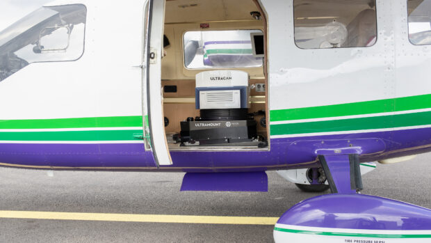
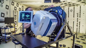
Bank: We fly exclusively with fixed-wing aircraft—manned planes. And we have over a hundred of them in the program, just in the U.S. Each of those planes has a flight crew and a Vexcel-manufactured sensor on it.
These sensors or cameras are about the size of a mini-fridge. They’re really complex pieces of equipment. They are made to do aerial survey. They’re mapping grade. So, they shoot in every direction as we fly along and they cover a very, very broad area.
We’re able to fly these aircraft—basically a lawnmower in the sky—back and forth, back and forth, collecting all of this data. It gives us imagery at multiple times higher resolution than high-resolution commercial satellites. So, it gives us that drone-level view but at continental scale.
Fitzgerald: Tell us what this allows insurers to do that’s different from what they currently do. And then, looking to the future, what is it positioning them to be able to do?
Bank: If an insurer uses geospatial data well and properly, it changes the entire experience—[for] underwriting, claims, pricing, risk management. But it also changes it for the end customer…
What’s unique about this program is it’s all built for AI. So, all of the data is completely identical in terms of how it’s collected, how it’s processed, where it’s sourced from, what sensor was used, everything. It’s one spec globally. And so, that means that you can train AI once and then use it repeatedly.
So, if you’re able to automate that, which is what a lot of our more advanced carriers are doing, [then] you can take those efficiencies. But it’s what you do with them that I think matters.
Let’s take a claims experience. A storm comes through, a fire comes through, [and] you had to evacuate. Your insurer can now call you and say, “Are you OK? You had to evacuate. Here’s the status of your house. Here’s what it looks like. Here’s your neighborhood. Fortunately or unfortunately, here’s what happened, but we’ll get through it. We’re here with you. What do you need? We got you a hotel room, a rental car. We’ll get you supplies and clothes and whatever off of Amazon.”
But at no point are we discussing that claim.
That’s both efficiency from the carrier’s perspective and [improved] customer experience from the customer perspective. You can create this bespoke, concierge-level experience all while doing it even more efficiently than you are now, because you often don’t have to put people in the field.
We’ve got large national carriers that are doing this at scale. They’re able to settle about 90 percent of their large loss claims from a catastrophe event within hours of having the imagery. Our imagery is available within 24 hours of collection…
Seeing the World at Different Angles
The Global Insurance Consortium’s operations partner, Vexcel, provides geospatial data using cameras and sensor technology aboard a fleet of fixed-wing aircraft to deliver images at multiple angles.
Included are:

Oblique images, giving a 45-degree multidirectional view of urban areas at 7.5cm or better.
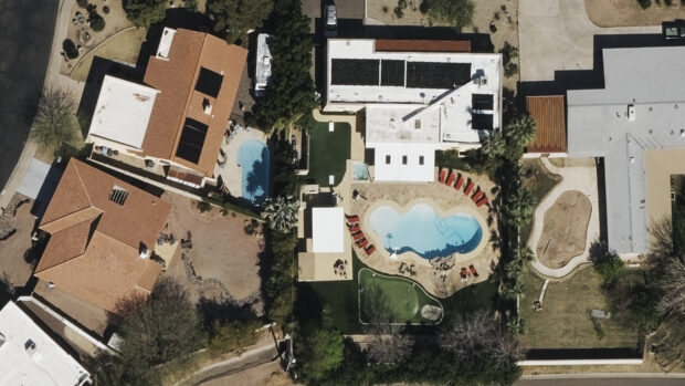
Ortho images, giving a straight-down aerial view of properties and locations at 20cm.
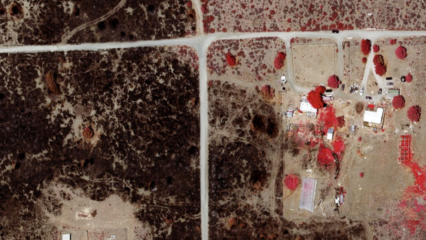
Multispectral or near-infrared (NIR) imagery, used to help classify vegetation and to assess and build better fire risk analyses.
Fitzgerald: There’s a subtlety here I’ve picked up from what you said I wasn’t aware of before. One of the issues with AI implementations is garbage in garbage out. Insurers collect a lot of data, and a lot of it is bad, a lot of it has to be categorized, or it has to be cleaned, or it has to be scrubbed and fill in the blanks. It’s an awful lot of work. It is a bigger barrier to success for a lot of AI initiatives… But if GIC is collecting this digitally already, it’s almost a greenfield data collection source…It’s a fresh set of data.
Bank: If you have quality in, you get quality out. There was no other program that we looked at where it had that homogenous data, but at the resolution that we need. We need to be able to see individual roof shingles, things like that. It’s not enough to just see a building.
And we have to do it at scale. So, it’s not enough to fly a drone over an individual house…
To me drones replace ladders. They don’t replace people. And here, what we can do is we can provide people with so much better information and intelligence—and we can do so in an automated way…
There are over 180 million insurable buildings in the U.S…How are you going to look at those?
We had one national carrier that was seeing their properties, on average, only every 12 [months] on renewal. Well, if you add a deck, if you add a swimming pool, if you had an addition, then that should flag something in a system that then pops up a warning and says, “Take a look at this. There’s a material change to this house. This was added.” That’s possible now…
Insurers don’t want to shy away from risk. They just want to understand it and price it appropriately. They want to insure good risk. And this quantification and qualification of what risk exists where can only be done through a dataset that provides the ground truth and a workflow that provides the scale.
Fitzgerald: Give us a view of what will be happening in three to five years. What will carriers be doing fairly commonly that they are doing rarely or not at all now? Paint the picture for us.
Bank: Beyond just imagery and 3-D geospatial data, I think the industry is also starting to benefit from using decision trees or complex AI to identify what factors actually cause risk.
An example would be maybe a trampoline…I wonder if the math would actually show if it’s a risk factor [directly resulting in claims] or if it’s a visual indication of your tolerance of risk as a homeowner. [Beyond] the fact that somebody [could] get injured from that trampoline, [maybe] the fact that you allow a trampoline to be in your home means that you’re probably OK with other risk factors as well…
Looking at tons of insurance data, claims data, property data could start to tease things like that out…We can start to look differently at how we evaluate what risk actually is, what risk is acceptable, what crosses the line, etc.
The future is about…doing things at a scale that we could never do, but to provide us more insight into the same kind of process that we’re dealing with now. I don’t think that [insurance] is going to be completely automated in three years. I just think that a lot of it will be, and [different types of tools] will be providing us better data to make better claims and underwriting decisions.
Photos provided by GIC and Vexcel
 The Race for California Insurance Commissioner: Meet Stacy Korsgaden
  Executive Viewpoint: One AI Won’t Save You
  Who Will Be California’s Next Insurance Commissioner?
  U.S. P/C Insurers Post Biggest Q1 Underwriting Profit in 25 Years