


Guest Editor

Allstate’s Telematics Strategy: Responding to Evolving Customer Needs
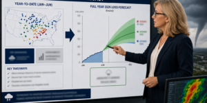
When consumers decide what to buy, they want companies to treat them as individuals: "Do you know my unique needs?" and "Will you be there for me when I need you?" For insurers, the answer to these ...
Repeat, Repeat and Repeat Again: How The Hartford Embeds IoT Capabilities in Commercial Insurance Businesses
The world is progressively witnessing heightened interconnectedness. Sensors present in physical objects capture data and link to digital communication networks. The data can then be analyzed, ...
Real-Time Data and Mitigation: How Tokio Marine Is Changing Risky Behaviors
In our ever more interconnected world—from vehicles to manufacturers to health care to the power grid—solutions to avoid risk are becoming more common. Our automobiles have evolved into veritable ...
Nationwide Insurance: Using a Decade of Learnings to Create Next-Generation Telematics Solutions
Telematics insurance has traversed more than two decades, cycling through phases of curiosity, dedication and subsequent disappointment. Only recently has the U.S. auto insurance sector acknowledged ...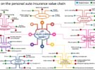
The Transformative Potential of Telematics Innovation: Personal Auto
When looking at the impact of telematics capabilities on insurance activities, we see the emergence of the transformative potential of this InsurTech innovation. There is a relevant number of ...
Creating the Tipping Point for Insurance IoT: How HSB and Its Partners Are Creating a Playbook for the Future
Over the past several years, the property/casualty insurance industry's use of Internet of Things (IoT) has significantly accelerated. Beyond auto telematics, P/C insurers—from major carriers to ...
The State Farm Vision: Ecosystem Capabilities for the Insurer of the Future
A century-old insurer is evolving to help people manage the risks of everyday life, recover from the unexpected and realize their dreams in an increasingly hyperconnected world. The State Farm ...