


When CM Guest Editor Mike Fitzgerald asked representatives of the Geospatial Insurance Consortium and InsurTechs Cape Analytics and Arturo to talk about data privacy issues they have had to deal with, he got what may have seemed like a surprising answer.
They haven’t run into any data privacy issues at all.
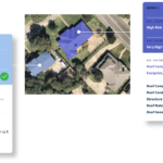
“I think that can be explained by a couple of factors. First, our imagery capture partners follow all national and local regulations that govern the capture of imagery. So, any images that Cape analyzes have already been vetted in that regard,” said Kayvan Farzaneh, chief of marketing for Cape Analytics, an InsurTech that uses geospatial imagery and machine learning to provide actionable property vulnerability and risk insights to insurers. (See related article, “Beyond Claims: How Carriers Use Geospatial Analytics to Underwrite Property,” to learn more about Cape Analytics.)
“Also, we focus exclusively on analyzing property characteristics and do not collect or transmit any personally identifiable information. For those reasons, we have not had the privacy challenges of other data sources, like credit, that are focused on individuals and their behavior,” Farzaneh said.
Ryan Bank, managing director of the Geospatial Insurance Consortium, a partnership between the insurance industry and Vexcel, a global aerial imagery provider, had a similar response. “We’re in public airspace with commercial aircraft looking down. So, you can’t identify faces yet. You can’t identify or read license plates. The physics just don’t work out because of the angle that we capture at. But we’re also flying where there’s no reasonable expectation of privacy.” (Related article: “A Top-Down View of Insurance Risk: Understanding the Geospatial Insurance Consortium“)
“We don’t take PII data,” he said, noting that GIC pushes imagery data to carriers, who then might overlay PII data.
“We’re just augmenting the data that they have,” he said, responding to a related question from Fitzgerald about regulatory issues. “Carriers aren’t basing product solely on this data yet. So, you don’t have to go get new rates approved or anything like that because it’s not changing it. It’s just giving you information that you could have gotten by sending a guy in a van with a ladder [to a property]. Now you can just do so automated and from the desktop.” (Related video, “Unlocking the Benefits of Geospatial Technology“)
Neil Pearson, chief strategy officer for Chicago-based Arturo, also said his company hasn’t run into privacy with respect to the AI its runs against images to derive property characteristics. “I suspect that unlike Drones and StreetView cars that frequent our neighborhoods, people don’t realize or see the planes that are flying over our cities at 6,000 feet. three to four times a year to capture such high-resolution imagery. So for this reason it isn’t seen as an invasion of privacy when compared with a drone buzzing overhead or when your house is being photographed by Google or Apple. Hence, where applicable, such companies allow property owners to have their homes removed from such consumer applications in the interests of privacy,” he said.
 The $400,000 Chief of Staff Is the CEO’s Secret Weapon in the AI Age
  Beyond the Weather News Bulletins: How Insurers Can Improve NatCat Responses
  Self-Driving Car Firms Must Address Emergency Vehicle Interference
  AI Pushes Underwriting Beyond Risk Selection to Prevention