


Hurricane Iota slammed into Central America late Monday with ferocious winds and rain, threatening to cripple a region already reeling from a deadly storm two weeks ago.
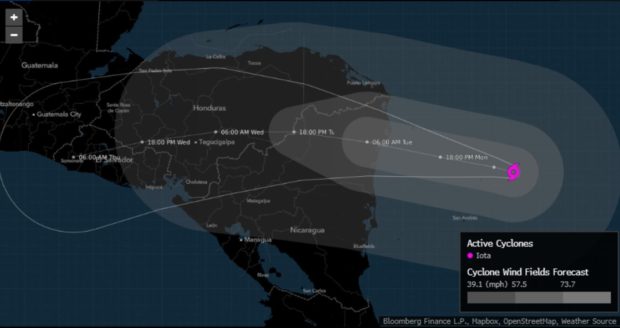
Iota, the most powerful Atlantic hurricane in a record-setting season, is moving along northeastern Nicaragua with winds of 130 miles (210 kilometers) per hour, strong enough to flatten homes, uproot trees and leave some areas uninhabitable for months. Iota is likely to trigger deadly mudslides and a humanitarian crisis, just weeks after Hurricane Eta killed more the 100 people and forced tens of thousands of people to evacuate.
“Catastrophic wind damage is occurring near Iota’s eyewall and these winds will spread farther inland across northern Nicaragua during the next several hours,” the National Hurricane Center said in an update. “A life-threatening storm surge will raise water levels by as much as 10 to 15 feet above normal tide levels in areas of onshore winds along the coast of Nicaragua and Honduras.”
Colombian President Ivan Duque Marquez said officials have lost contact with the island of Providencia, off the coast of Nicaragua. The country’s army and navy are standing by to mount rescue operations as soon as the storm passes, he said.
Iota is the 30th named storm in the Atlantic this year, a record. The hyperactive hurricane season is part of a string of natural disasters in 2020, including deadly wildfires in the western U.S. and a derecho that left wreckage from Iowa to Indiana. They’re further evidence that the Earth’s climate is changing, threatening to bring more widespread devastation.
“The storm should make us reflect on what is happening and what has become the most vulnerable region in the world to climate change due to the effects of large industrial nations, but we suffer the consequences,” Guatemala President Alejandro Giammattei said at a meeting with the Central American Bank for Economic Integration, calling for green funds for climate change. “It’s not fair for us to continue going into debt to rebuild our countries and repair damage to infrastructure and agriculture.”
This is the first time the Atlantic has produced two major hurricanes — Category 3 or stronger — in November, according to a tweet by Phil Klotzbach, lead author of the Colorado State University seasonal forecast. Iota is the first storm to reach Category 5 strength so late in the year, he said.
Iota could create additional problems for coffee and sugar crops in the region, which were drenched by heavy rains and flooding from Eta two weeks ago, said Don Keeney, a meteorologist with commercial forecaster Maxar. Honduras is the top coffee grower in the region, followed by Guatemala, which is the biggest cane-sugar exporter in the area and a key supplier of the sweetener in the world.
Guatemala’s ports have already slowed due to heavy rains and an ongoing La Nina weather pattern in the Pacific, and Iota “could complicate” things, Michael McDougall, managing director for Paragon Global Markets, said in an emailed note.
While Iota’s winds could fluctuate as it comes ashore, it won’t really matter because widespread damage is inevitable now, said Dan Kottlowski, a meteorologist at commercial forecaster AccuWeather Inc.
“This is a humanitarian disaster in the making,” Kottlowski said.
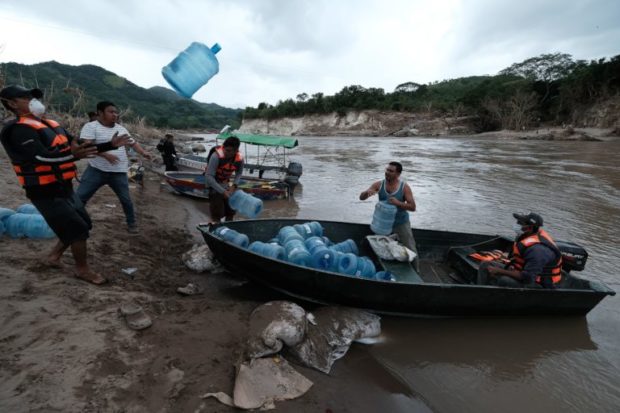
Thousands have already evacuated in Honduras and Nicaragua, and Guatemala is preparing emergency food kits. The storm will devastate the coastal areas with high winds and deadly storm surge before wringing out flooding rains across the mountains of Central America for the next four days.
So many systems have formed in the Atlantic this year that the National Hurricane Center used up its official name list in mid-September and resorted to using Greek letters to designate tropical cyclones.
–With assistance from Andrea Jaramillo and Michael McDonald.
Photograph: People from San Rafael colony prepare for water shortages as they evacuate before the arrival of Hurricane Iota on Nov. 16, 2020 in Santa Barbara, Honduras. Photo credit: Yoseph Amaya/Getty Images
 Preparing for an AI Native Future
  Nearly 26.2M Workers Are Expected to Miss Work on Super Bowl Monday
  Flood Risk Misconceptions Drive Underinsurance: Chubb