


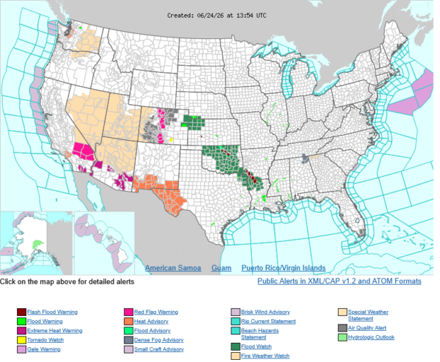
Much of the U.S. is expected to endure extreme weather conditions this week, according to a forecast issued today by the National Weather Service.
Severe weather and flooding threats will continue for portions of the central U.S. over the next couple of days, with multiple rounds of thunderstorms expected, according to the weather agency’s forecast.
Dangerous heat is expected to persist across the southern and western U.S. through mid-week. Hot and dry conditions will fuel fire risk in the West, where dry thunderstorms may spark additional wildfires.
The strongest severe storms could produce damaging winds, large hail, heavy rainfall, and a few tornadoes from the High Plains into the Ozarks.
While the Midwest will see cooler than normal conditions, parts of the West, Southern Plains, and Florida will continue to bake under intense heat the next two days. High temperatures could reach the 90’s into the triple digits.
Western states will see relief by Friday, when cooler temperatures take over.
 Default Speed Limit in Iowa Changes from 55 to 60MPH
  AI Adoption Continues, But 70% Want More Training: SMB Survey
  Two Trailers Containing $1.3M in Stolen Copper Wire Recovered in Illinois
  Reframing Like a Fox: How Insurance Leaders Can Catch Strategic Drift Before It Compounds