


















Tropical Storm Beryl strengthened into a hurricane on Saturday, according to the National Hurricane Center.
In an advisory issued this morning, satellite imagery and Barbados radar data indicated that the eye of Beryl has made landfall on Carriacou Island.
Data obtained from Hurricane Hunter aircraft indicates the Atlantic Season’s first hurricane has maximum sustained winds of 150 mph (240 km/h).
The advisory indicated the hurricane is causing life-threatening winds and dangerous storm surges.
Hurricane Warning is in effect for Barbados, St. Vincent and the Grenadine Islands, Grenada and Tobago.
A Hurricane Watch is in effect for Jamaica.
Fluctuations in strength are likely during the next day or so, according to the NHC.
Beryl is expected to remain an extremely dangerous major hurricane as its core moves through the Windward Islands into the eastern Caribbean.
 Human Error, Systemic Failure Blamed for Spain’s Latest Deadly Train Crash
 Why Carrier AI Rollouts Stall: Three Types of Resistance Executives Should Treat Differently
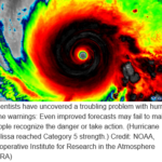 Despite Improved Hurricane Warning Maps, Public Understanding of Danger Lags
 Workers’ Compensation’s Real Challenge: Orchestration