


New funding under the Biden-Harris administration will allot $80 million, through the Investing in America Agenda, to assist the National Oceanic and Atmospheric Administration’s efforts to upgrade the National Water Model and expand Flood Inundation Mapping services.
Last month, the Department of Commerce and NOAA’s Office of Water Prediction awarded the Next Generation Water Prediction Capability contract to Raytheon, an RTX Business.
According to the weather agency, “the $80 million, four-year contract will transform water prediction by enabling rapid deployment of advanced water models to provide coupled, continental scale, operational coastal and inland flood forecasting and inundation mapping services.”
The contract will allow the development of a new Water Resources Modeling framework supporting the National Water Model with state-of-the-science hydrologic and hydraulic model formulations. In addition, it will allow the development of near real-time, high spatial resolution flood inundation maps and services for almost all of the U.S., leveraging forecasts from National Weather Service River Forecast Centers and operational guidance from the National Water Model.
“Floods can have devastating impacts across the country, harming local economies, damaging infrastructure, and putting lives at risk,” said U.S. Secretary Gina Raimondo. “This investment, made possible by President Biden’s Investing in America Agenda—a key pillar of Bidenomics—will give first responders, emergency managers and the public better, fast information about where, when and how our communities will be affected by flooding.”
Under the contract, Raytheon will be required “to deliver an integrated, high-resolution hydrographic, topographic and bathymetric geospatial dataset underpinning both the National Water Model and Flood Inundation Mapping service capabilities, and a cloud-hosted Optimization and Evaluation Environment to configure the new National Water Model and Flood Inundation Mapping services.”
The new capabilities will allow operationalization of the new models and will enable broad community engagement as envisioned in NOAA’s Weather, Water and Climate Strategy.
In addition to running models that predict streamflow, floods and inundation, the new Water Resources Modeling framework also will provide an avenue to deploy improved models of drought, soil moisture and water quality into operations, NOAA said in a statement on the funding.
“NOAA’s National Weather Service is taking flood forecasting to the next level,” said Dr. Michael Morgan, the assistant secretary of Commerce for Environmental Observation and Prediction. “This project is expected to enhance our ability to identify and communicate potential flooding and pass that life-saving information on to emergency managers, decision makers and the public.”
The agency also announced it had awarded $7.4 million, of which $1.7 million is Bipartisan Infrastructure Law funds, to GAMA-1 Technologies to develop the Hydrologic Visualization and Information Services system in the cloud to serve as the platform for dissemination of high-resolution flood prediction services to the nation.
Source: NOAA
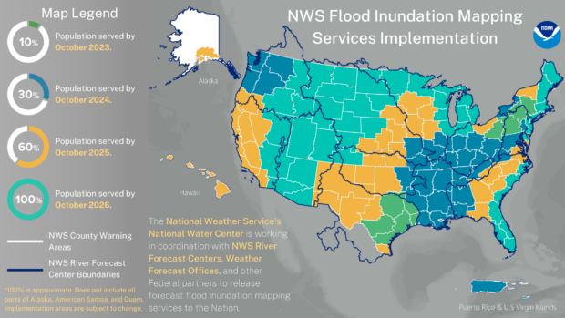
Featured Map: NOAA’s new experimental flood inundation maps are currently available to 10 percent of the population, shown in green. These services will expand to nearly 100 percent of the population by 2026. (Image credit: NOAA)
 How Doublet Earthquakes That Struck Venezuela Happen
  Illinois Could See Highest Catastrophe Claim Volume in a Decade: State Farm
  Supply Shocks Beyond Hormuz: Other Ports Face ‘High’ Risk of Disruption
  Second U.S. Safety Agency Investigates Fatal Texas Tesla Crash