


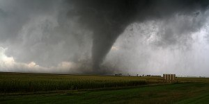


The odds of a La Niña weather pattern this year are rising, amplifying the risk of hurricanes in the Atlantic and drought in California and South America.
There’s a 55 percent chance that La Niña, a cooling of the equatorial Pacific, will occur between June and August as the strong El Niño that’s currently roiling weather around the world fades, U.S. Climate Prediction Center said Thursday.
“I think there is potentially a fairly rapid transition ahead of us,” said Michelle L’Heureux, a meteorologist at the agency.
La Niña threatens to unleash powerful hurricanes because it cuts down on shear, or winds blowing at different strength or directions at varying altitudes. It can also shift rain away from the U.S. West and crop-growing regions in Argentina and Brazil, triggering drought.
While about 60 percent of strong El Niños have been followed by La Niñas, L’Heureux said no one should bank on that shift quite yet for 2024 because outlooks made before March aren’t as accurate as those made at other times of the year.
The Pacific’s surface is still quite warm, meaning El Niño is holding on, L’Heureux said. But below 100 meters (328 feet), she said, the ocean is getting cool — a sign that things are changing.
Photo: A news reporter walks onto a dock ahead of Hurricane Idalia in Cedar Key, Fla., Aug. 29, 2023. Photographer: Christian Monterrosa/Bloomberg
 Most American Workers Are Checked Out, and Like ‘The Office,’ Their Bosses Are the Last to Know
  Trafficking Enterprise That Stole More Than $8M Cars Busted in New Jersey
  Viewpoint: Boom in Hyperscale Data Centers Puts Insurers to the Test
  Illinois Could See Highest Catastrophe Claim Volume in a Decade: State Farm