


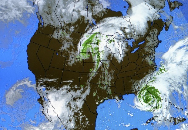
The Atlantic hurricane season is about to enter its most active phase as conditions for the powerful storms improve across the basin.
Wind shear that can tear budding storms apart has been decreasing, said Dan Kottlowski, an expert senior meteorologist at AccuWeather Inc. in State College, Pennsylvania. At the same time, the potential for more robust tropical waves, the seeds for hurricanes, is increasing.
The U.S. National Hurricane Center is currently tracking such a wave just off the coast of Africa. It has a 20 percent chance of becoming a tropical system in the next five days.
“There are six or seven blobs of thunderstorms marching across Africa right now, some of these will be tropical waves,” Kottlowski said by telephone. “Next week looks very promising for development over the eastern Atlantic.”
The Atlantic season begins on June 1 and the most active portion falls between Aug. 20 and October. Sept. 10 is the statistical peak of the period, according to the center in Miami.
The storms are followed closely by energy companies and commodities traders because they can destroy crops and disrupt natural gas and oil production and processing.
Gulf Impact
The Gulf of Mexico is home to about 6 percent of U.S. natural gas output, 23 percent of oil production and more than 40 percent of petroleum refining capacity, according to the Energy Department. The Bay of Campeche, at the southern end of the Gulf, is where Petroleos Mexicanos, Mexico’s state-owned oil company, has most of its production.
Florida is the second-largest producer of oranges after Brazil.
The 30-year average for the Atlantic season is 12 storms with winds of at least 39 miles (63 kilometers) per hour, the level at which they are named, the hurricane center said. Thirteen to 19 named storms are expected this year, according to a National Oceanic & Atmospheric Administration outlook issued last week.
Four Storms
Four storms have already formed in the Atlantic basin this year, putting the season ahead of schedule. The fourth storm usually forms by Aug. 23, center data show.
While activity in the Atlantic may increase next week, the threat to the U.S. and the Gulf of Mexico will probably be low, said Matt Rogers, president of Commodity Weather Group LLC in Bethesda, Maryland.
“The waves have been getting more robust but the models have been having trouble keeping them going across the Atlantic,” Rogers said.
Computer models in North America and Europe show any storms developing next week falling apart before they get to the U.S., he said.
In addition to the wave off Africa, the center is tracking a broad area of thunderstorms in the southwestern Caribbean Sea. It has a 30 percent chance of becoming a system in the next five days.
Rogers said he doesn’t believe it will have enough time to develop into a strong, organized tropical system before going onto land.
“My feeling on that system is it is a very low risk, probably zero, on Gulf production threat,” Rogers said.
Kottlowski said the greatest impact may be that part of the cluster breaks off and takes more heavy rain across the southeastern U.S.
“They have had more than double their normal rainfall for the last 30 days, there could be major flooding issues in the southern Appalachian mountains,” Kottlowski said.
Editors: Charlotte Porter, Richard Stubbe
 Why Consistency Beats Creativity in Insurance Marketing
  Wendy’s, Chipotle Not Affected by Cyclosporiasis Outbreak
  Home Trend Report: Severity Reaches All-Time High, Frequency Declines
  Rising Pro Boxer Killed While Riding Bicycle in Bizarre Texas Crash


