


flood maps News
Drenching In California: Most Homeowners Have No Flood Insurance
Last Sunday morning, Kyle Starks woke up to floodwaters that reached the door of his Jeep after yet another heavy rain storm drenched California. Emergency crews showed up with boats to float Starks ...
Climate Change Is Overwhelming U.S. Flood Maps, FEMA Head Says
Flood maps used by the Federal Emergency Management Agency are out of date and understate the risks to homes and businesses from flooding and extreme rain triggered by climate change, according to ...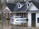
New Flood Risk Maps Designed to Address Major Government Deficiencies
First Street Foundation, a nonprofit agency, is making accurate climate change-adjusted flood scores available for every property in the U.S. today. There are government-produced maps showing 8.7 ...
Insurers Worry Canada’s Climate Change Flood Mapping Work Will Take Too Long
Canada plans to focus its next budget on tackling climate change and its effects but the insurance industry, amid skyrocketing costs, is concerned the government will move too slowly on the key first ...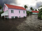
Foundation Is Working to Report Flood Risk for Every U.S. Property
A group of scientists and a technology nonprofit technology organization have set a mission to calculate the past, current and future flood risk of every property in America. While institutional real ...
Trump’s Proposed Flood Map Program Cuts Could Trigger Higher Insurance Rates
A proposal by the Trump administration to cut $190 million in funding for updating U.S. maps of flood-prone areas would trigger higher insurance rates or more homebuilding in risky locations, a ...