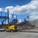


A wildfire that quickly spread across the Hawaiian island of Maui last week will likely be responsible for the second worst disaster, in terms of insured losses, in Hawaii’s history.
Karen Clark & Company (KCC) estimates the Lahaina Fire will be second only to Hurricane Iniki based on today’s property values.
According to KCC, Maui has experienced two wildfires during the past 20 years that started within 10 miles of the Lahaina fire: the Olowalu Fire in 2007 resulted in 2,500 acres burned, and the Maalaea Fire in 2016 burned 6,000 acres.
Though FEMA currently estimates 1,800 burned structures in Lahaina, KCC analysis forecasts a much higher number of buildings damaged by the fire, based on about 3,500 buildings within the fire perimeter.
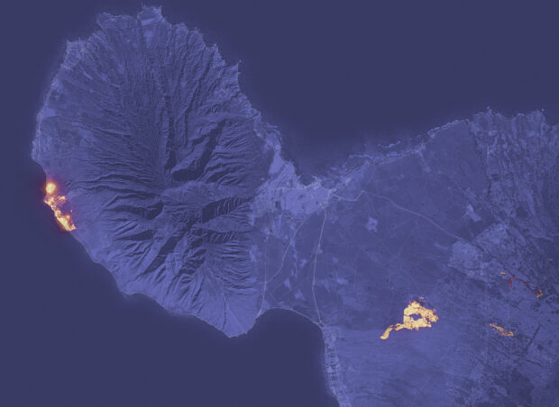
CoreLogic estimated approximately 3,088 single- and multi-family residential properties with a combined reconstruction value of $1.3 billion are within three preliminary wildfire perimeters (unofficial) on Maui.
Using satellite-derived wildfire hot spot data from the National Oceanic and Atmospheric Administration (NOAA), CoreLogic created preliminary wildfire perimeters on the island of Maui.
Most residential properties are located in Lahaina, CoreLogic added.
“Fires in Hawaii tend to break out in large grasslands on the dry sides of the islands; in Maui, the drier sides are the leeward areas to the west and south,” the KCC advisory stated.
Approximately 2,200 acres have burned, KKC analysis indicated as of Friday, Aug. 11. Thousands of residents and tourists evacuated the island last week, and Maui County officials report 96 confirmed fatalities. In addition, there are widespread power outages reported.
The official cause of the fire remains under investigation, though wind gusts and wooden structures hastened the destruction, according to Jon Schneyer, director of Catastrophe Response at CoreLogic.
 Insurer Interest in AI Exclusions Growing as Risk Becomes Omnipresent
  Tesla’s Cratering Cybertruck Sales Evoke Ford Edsel Comparisons
  This Year’s SCS Loss Totals Will Fall Below Average: KCC Analysis
  Berry Producer Driscoll’s Sued Over Alleged Use of Forever Chemicals