


Oil spills, port explosions, blockages in the Suez Canal and supply chain risks. These are just some of the events that global space company Skytek has analyzed over the past year for its insurance industry customers.
Executive Summary
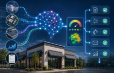
Skytek is a developer of software solutions for industry, with products derived from space and satellite technology, including REACT, a one-stop geolocation and satellite positioning service for the insurance sector and other industries. Here, CEO Dr. Sarah Bourke describes some of the use cases of REACT, both in assessing property claims involving fixed and mobile assets before and after loss-causing events, and risk scores for upfront underwriting of marine risks and other global assets.The company helps insurers manage their global positions, combining space technology, big data, artificial intelligence (AI) and machine learning—in a service called REACT. With REACT, Skytek tracks both mobile and fixed assets around the world, in real time, both before and after loss events, said Skytek’s chief executive officer, Dr. Sarah Bourke, in an interview with Carrier Management.
“We can now tell you, in near real time, where all your assets are, what your aggregations are, what your accumulations are. We can track what your assets are doing and where they are traveling to.”
The system can count all the cars and the containers in ports across the globe that are in an insurer’s portfolio. “It’s a whole new way of looking at your risk and managing risks,” she affirmed.
With its earth observation imagery, Skytek works with insurers and brokers during the U.S. windstorm season in America to provide pre- and post-event imagery to identify affected assets in a portfolio.
 “We’re able to tell the insurance companies all the details about the vessels, such as their flag, their classification and society. We’re also able to give them a flavor of the voyages, so they’re able to see how many miles a vessel has sailed in a year, where did they go and what ports they called at.”
Dr. Sarah Bourke, Skytek
Despite such accurate and fast real-time analysis, Bourke does not think that this technology will replace risk and catastrophe models. She said this technology complements such models by providing more granular data—cargo accumulation at ports and satellite imagery for pre- and post-loss assessment, for example.
Skytek can validate a model because “we can tell you in real time where are your top five exposures in the world,” she said.
Ever Given in the Suez
One example of Skytek’s service involved the giant container ship Ever Given, which ran aground in the Suez Canal in high winds on March 23 this year, halting traffic for weeks in both directions and disrupting global trade. Skytek provided insurers with both satellite imagery and an analysis of exposed assets. (Related video: “On the Ground: How Insurers Can Use Geospatial Information Systems“)
The minute people realized there was a problem in the Suez Canal, the Skytek system was able to react and insurers could monitor their portfolios. She explained, “Our insurance company clients have portfolios within our system. So, they knew immediately what assets were in the area at the time.”
During the COVID-19 crisis, Skytek was asked to analyze the risk accumulation of cruise ships, given the fact that vessels were laid up and billions of dollars’ worth of risk were situated in one location. In just one of its findings, Skytek discovered that England’s Port of Southampton had gone from having no risk to $5 billion worth of cruise ship risk in the period from March to October 2020, Bourke explained.
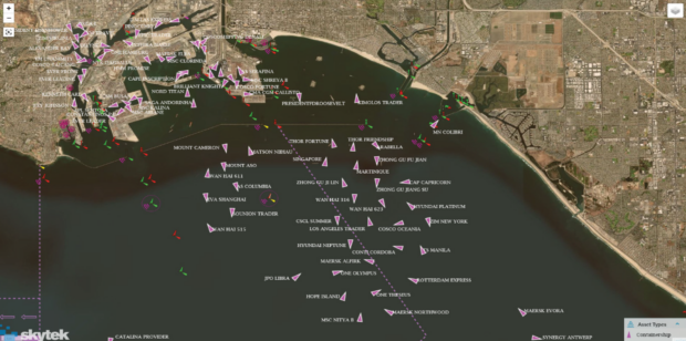
Cargo accumulation and delays are a major news story for 2021. Using its latest earth observation and AI technology, Skytek can assist carriers to understand global supply chain issues. Indeed, a Skytek analysis of Los Angeles port in September showed the enormous scale of the problem.
Unmodeled and Modeled Catastrophes
Skytek’s services also were used after the deadly Port of Beirut explosion on Aug. 4, 2020, when a large amount of ammonium nitrate stored at the port exploded. Skytek was easily able “to tell the insurance sector about the expected loss in Beirut” by examining pre- and post-loss imagery.
There was relief provided for the sector in the wake of the event because Skytek was able to quickly confirm that several container vessels in the port were not destroyed. Bourke said insurers find it helpful to be able to access that kind of information quickly.
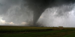
Skytek also tracks windstorms as part of its catastrophe toolkit. “We’re able to tell insurance companies where their assets are and what’s the value of the assets in the cone of uncertainty.”
Using its earth observation imagery, which employs satellite imagery, AI and machine learning, Skytek can determine the location of insurers’ assets and perform pre- and post-event comparisons. In other words, it analyzes images from all available external resources, such as the National Oceanic and Atmospheric Administration (NOAA).
Skytek also tracks oil spills and leaks, detecting what vessels were in the affected area at the time and the likely candidates that committed the environmental issue, according to Bourke. Skytek has tracked the recent oil spill off the coast of California and is currently investigating the scale of the event using its satellite technology.
Space to Innovate: Front-End Underwriting
Skytek also can help insurers with their underwriting—at the front end of a risk.
For example, with a marine portfolio, the system provides analysis at both vessel and portfolio level. “We’re able to tell the insurance companies all the details about the vessels, such as their flag, their classification and society. We’re also able to give them a flavor of the voyages, so they’re able to see how many miles a vessel has sailed in a year, where did they go and what ports they called at.”
Insurers can compare an individual ship’s data points to the global fleet. “Is it underperforming or overperforming?”
Skytek also provides risk scores for each asset tracked by its REACT platform. “For example, we take things like the age of the vessel, the type of vessel, the flag it sails under, and then we assign a risk score,” Bourke explained.
When underwriters log into the REACT system, they get a risk score for a vessel and for a portfolio.
While this information is publicly available from about four or five different sources, Skytek pulls it all together into one easily accessible platform, she said. “Even though we’re very sophisticated in what we do, the user interface is really simple, so you don’t need to be in any way technical. You just log in, get your information, and off you go. That’s really it.”
ESG Risk Scores
In addition to natural catastrophes and manmade events, such as port explosions, Bourke said the company also helps customers analyze compliance with environmental, societal and governance (ESG) risks and impact assessments. “That’s keeping an eye on things like CO2 emissions, deforestation and shipping activity in environmentally sensitive areas.”
Last year, there was a lot of focus on sanctions compliance related to Iran, for example. “This year, however, the focus of a lot of CEOs and boards of insurance companies is on ESG compliance.”
“Ships have a very heavy environmental footprint, and so now the focus is on monitoring and that kind of activity.” As a result, Skytek also is providing ESG risk scores for vessels. “You have to be able to pivot, depending on what’s happening within the industry.”
Above the Clouds
Skytek doesn’t own or develop satellites; it has relationships with providers. “The big challenge is tasking the satellite. We task the satellite, we get the images, and then we give them to the insurance companies,” said Bourke.
Skytek has strategic partnerships with NASA and the European Space Agency (ESA) as well as leading European companies and organizations such as Airbus and EUMETSAT. It also has a long-term strategic relationship with insurance broker Aon, according to Skytek’s website.
Dublin-headquartered Skytek was launched in 1997 as a software company, specializing in the space industry. It now has clients all over the world. One of its key projects was to develop the International Procedure Viewer (iPV) system, which has been used on the International Space Station (ISS) for more than a decade.
Like a very sophisticated technical manual, the iPV system contains more than 15,000 procedures used by the astronauts on the ISS to guide them through routine procedures and mission-critical events such as space walks and emergencies. Its iPV procedures also are employed on Elon Musk’s SpaceX missions to the ISS.
Skytek has won awards from NASA and the EU for outstanding innovation, “so we do regard ourselves as being technology innovators,” said Bourke. “That’s the experience we’re bringing to the insurance industry.”
In addition to insurance, Skytek has also developed intelligent software solutions for other industries, such as marine transportation, energy, aerospace and defense.
“Our whole legacy has been with the space industry. We understand the industry; we understand all the technologies there. And that’s the tried, tested and trusted expertise that we’re bringing to the insurance industry.”
Edited by Mike Fitzgerald, CM Guest Editor.
Guest Editor Mike Fitzgerald described Skytek’s analysis of the Ever Given incident in a related video, “Seeing Through Clouds: CM Roundtable Highlights”
(This article appeared in Carrier Management’s fourth-quarter magazine. Click the “Download Magazine” button for a free PDF. To read and share individual articles more easily, become a Carrier Management member to unlock everything.)
 Insurance AI: What You Won’t Read in the Press Releases
  The 24-Hour Window: The Race to Keep Claims Out of Litigation
  Supply Shocks Beyond Hormuz: Other Ports Face ‘High’ Risk of Disruption
  How Insurers Know When It’s Time to Scale AI