


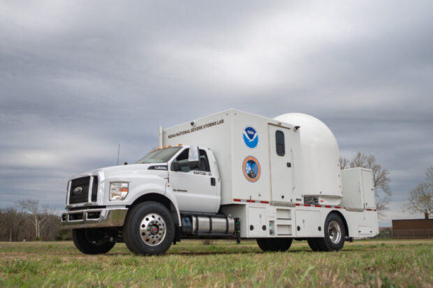
Three new mobile weather radars were unveiled by NOAA National Severe Storms Laboratory (NSSL) last month, allowing researchers to deploy research-grade technology to the front lines of tornadoes, wildfires, hail storms, flash flooding, and severe wind events, significantly expanding real-time insight into hazardous weather threats.
“This is a game changer for public safety,” said DaNa Carlis. Ph.D., director of NOAA’s National Severe Storms Laboratory. “We aren’t just increasing our numbers from one radar to three; we are fundamentally upgrading the quality of data we can provide to forecasters and decision makers. These tools allow us to observe and document extreme hazards with a level of detail and confidence that was previously impossible.”
The state-of-the-art mobile radars are designed to be rapidly deployed during dangerous weather, giving researchers detailed views of atmospheric processes that are difficult or impossible to capture with the agency’s fixed radar network alone.
Mounted on heavy-duty trucks and equipped with working space for researchers to operate, the new radar comprises two X-band (three cm wavelength) radar units and one C-band (five cm wavelength) radar.
The shorter wavelength X-band radars are more sensitive and can see smaller drops and particles more effectively, while large drops or dense concentrations of drops can cause data quality issues. The larger wavelength C-band radar performs better for heavy precipitation measurements and large particles.
Mobile radars can scan the lowest levels of the storm where hazards like tornadoes occur,” said Pam Heinselman, Ph.D., deputy director of NSSL. “This gives us the most detail possible in the areas where people are impacted.”
The improved data collection is valuable for studying tornadoes and severe storms, where small-scale features can have major impacts. High-resolution radar data can reveal rapid changes in wind patterns and storm organization that influence storm strength and longevity, the agency stated.
“Having multiple radars scanning one storm also gives us vastly better data,” said Kurt Hondl, NSSL associate director. “A radar can only measure wind speeds towards or away from the radar. If you have two radars looking at the same area from different viewpoints, you can use the two observations to determine the wind speed and direction.”
The new radars will also support research into other high-impact hazards.
In wildfire situations, mobile radars can help monitor smoke plumes, fire-induced winds, and changing weather conditions that affect fire behavior and firefighter safety.
During flash-floods, the new radars can pinpoint where the heaviest rain is falling in real time, helping communities prepare for sudden and life-threatening floods.
The three new radars strengthen NSSL’s mobile observing fleet, including mobile mesonets, precipitation-monitoring tools, uncrewed aerial systems (UAS), lightning mapping array, HailCam, and LiDAR. Researchers from NSSL take these tools into the field and collect detailed measurements of wind, precipitation, and storm structure during critical moments. By sampling weather systems at closer range and from multiple angles, researchers can better understand how severe weather forms, evolves, intensifies, and dissipates.
“The data collected by the new mobile radars won’t just sit in the lab,” said Carlis. “It will help refine NOAA weather forecasts and protect lives and property by giving people more time to seek shelter ahead of an oncoming severe storm.”
 Most American Workers Are Checked Out, and Like ‘The Office,’ Their Bosses Are the Last to Know
  Engine Failure Not a Factor in Fiery Skydiving Plane Crash That Killed 12
  Insurance AI: What You Won’t Read in the Press Releases
  Agent-Carrier Relationships Improving, Survey Shows