


After a destructive 2024 season marked by five major hurricanes—including multiple Category 5 storms—forecasters are warning of even greater activity ahead. NOAA projects up to 25 named storms this year, and Colorado State University predicts a season 125% more active than average.
Fueling these projections are warmer-than-average sea surface temperatures in the Atlantic and an expected transition to neutral El Niño Southern Oscillation (ENSO) conditions by August. These climate signals point to a heightened threat level across many coastal regions, reinforcing the need for precision in how insurers, emergency planners, and property owners assess hurricane risk.
According to the U.S. National Climate Assessment, hurricanes in the North Atlantic are not only lasting longer but also becoming more intense. Rapid intensification events, where storms jump from Category 1 to Category 3 or higher within a 24-hour window, have more than doubled since the 1990s, according to reporting from the Associated Press. Researchers from NASA and other climate groups have found that warming oceans are also contributing to more powerful winds, heavier rainfall, elevated storm surge levels, and increasingly destructive flooding.
In response to these escalating risks, Guidewire HazardHub provides the industry’s most granular hurricane and storm surge risk data, with detailed insights for every property in the United States. These risk scores help insurers better evaluate exposure and support community resilience planning.
At the Center of the Storm
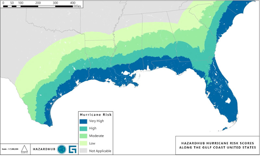
Florida stands out as the epicenter of hurricane risk in the U.S. Based on HazardHub’s Hurricane Risk Score, the state has the highest concentration of properties rated “D” (high risk) and “F” (very high risk) for hurricane vulnerability. In total, about 3 million homes in Florida are considered at risk of storm surge flooding, representing 34% of all housing units in the state.
Texas also ranks among the most hurricane-exposed states, particularly along the Houston-Galveston corridor. While only about 5% of homes in Texas are located in areas flagged for storm surge risk, the state’s sheer population means millions of people and properties remain highly exposed.
Along the Gulf Coast, Louisiana leads the nation in storm surge vulnerability. Approximately 52% of homes in the state, more than 900,000 properties, are at risk of flooding from hurricane-induced surge. Mississippi also faces serious exposure, with 9% of homes at high risk, and Alabama follows with 3%. These three states frequently experience both direct hurricane landfalls and prolonged flooding from slow-moving tropical systems.
Turning to the Southeast, South Carolina shows particularly high vulnerability, with 21% of all housing units located in surge-prone areas. In Georgia, about 4% of homes face similar risks, concentrated primarily in coastal cities like Savannah. North Carolina rounds out the regional picture with 7% of homes exposed to storm surge and hurricane wind threats.
In the Mid-Atlantic and Northeast, Delaware reports a 20% storm surge exposure rate—among the highest outside the Gulf region. Virginia follows with 13%. While New York and New Jersey do not rank among the most vulnerable states by percentage, HazardHub data identifies specific risk zones in coastal areas such as Long Island and the Jersey Shore, where northern-shifting storms can still inflict major damage.
Top States for Hurricane Risk
Based on HazardHub’s Hurricane Risk Model, the ten states facing the highest risk—measured by the percentage of properties rated “D” or “F”—are:
- Florida
- Louisiana
- South Carolina
- Texas
- Mississippi
- North Carolina
- Delaware
- Georgia
- Alabama
- Virginia
Hurricane Storm Surge
These same states also rank highly for storm surge exposure, as measured by HazardHub’s SurgeMax Storm Surge Flooding Model. Louisiana leads with 52% of homes at risk, followed by Florida at 34%, South Carolina at 21%, Delaware at 20%, and Virginia at 13%. The remaining states—Mississippi, North Carolina, Texas, Georgia, and Alabama—each show between 3% and 9% of housing units in high-risk surge zones.
Building Resilience
But risk awareness is only part of the story. Many of these same high-exposure states are also investing in data-informed resilience strategies. In Louisiana, the state’s Coastal Master Plan has become a national model for integrating levees, wetland restoration, and engineered barriers to defend against surges and erosion. Florida is providing grants for vulnerability assessments and adaptation infrastructure through its Resilient Coastlines Program. South Carolina‘s Office of Resilience is acquiring flood-prone properties and converting them to open green space through its Voluntary Buyouts Program. And in New York, the NY Rising Initiative and Resiliency Institute have reformed city zoning codes to promote flood-resistant buildings in the wake of Hurricane Sandy.
Risk Models and Granular Data for Risk Resilience
HazardHub’s high-resolution, parcel-level data on hurricane risk, storm surge exposure, and dozens of additional perils offers insurers, communities, and property owners the insights they need to better understand exposure, prioritize mitigation, and strengthen resilience. With more than 1,000 property-level data points and over 50 peril scores, including its flagship Hurricane Risk Score and SurgeMax Model, HazardHub enables smarter decisions about where and how to plan, price, and protect.
As storm activity escalates and geographic exposure shifts, real-time, location-specific risk data has never been more essential. For insurers seeking to strengthen their portfolios and communities aiming to build smarter, HazardHub delivers the clarity required to act with confidence.
 Using Aerial Imagery in Insurance and Related AI: Emerging Regulatory Themes
  Berkshire Hathaway to Invest $1.8 Billion in Tokio Marine
  Four More Injuries Tied to Hyundai Palisade SUV Rear Power Seat Recall