


According to catastrophe modeling firm AIR Worldwide, heavy rainfall, severe thunderstorms, and flash flooding tore across several Midwest states early last week, after moist air surged ahead of a strong cold front and low-pressure system. While the worst of the rainfall has passed, many rivers are still swollen. Flood warnings remain in effect from Michigan to northern Arkansas and Tennessee.
As of Monday morning, more than 200 gauges were in flood stage along rivers in the upper Midwest, including 43 in “major” flood stage.
Illinois has been particularly hard hit with nearly seven inches of rain measured at Chicago O’Hare Airport in 24 hours. Flooding has backed up drainage systems and caused transportation disruptions across the state. A state of emergency has been issued and by Monday Illinois Governor Pat Quinn had declared 44 counties disaster areas.
The wide extent of the heavy rainfall caused at least 12 gauge sites on six rivers in northern Illinois to crest at their all-time record high levels, forcing the evacuation of hundreds of homes and businesses. The Des Plaines River in Chicago crested 1.5 feet above the all-time record of 10.9 feet. The Illinois River at Peoria is expected to continue rising this week and crest at 29.9 feet. That would break the record height of 28.8 feet established on May 23, 1943.
On Friday, Missouri Governor Jay Nixon also declared a state of emergency and activated the Missouri National Guard in a bid to help local towns.
According to AIR, following months of drought, parts of the Mississippi River are nearing flood stage and communities located along the river are closely monitoring water levels. The surging Mississippi is at or near crest at several places from the Quad Cities south to near St. Louis—some reaching 10 – 12 feet above flood stage. The U.S. Army Corps of Engineers anticipates that the river will crest at 35 feet on Tuesday as compared to the 2011 Great Mississippi River Flood when the river crested at nearly 48 feet. Sandbags were deployed in some areas and residents in these and other areas are making preparations to evacuate low-lying locations.
On Saturday, the mayor of Grand Rapids, Michigan, declared a state of emergency. On Sunday night, the Grand River peaked at more than two feet over flood stage—reaching a level of nearly 22 feet and topping the previous record of 19.6 feet set in 1985.
According to AIR, the flooding began when a persistent weather pattern brought tornadoes, hail, damaging winds, and large quantities of precipitation. This potent area of low pressure developed over northwest Texas last Tuesday night and tracked northeastward toward the Great Lakes over the course of the next three days. In addition, a steady stream of warm, humid air from the Gulf of Mexico ahead of the system provided ample moisture for heavy rains to move over Missouri, Iowa, Illinois, Michigan, Indiana, and western Kentucky and Tennessee. Some areas in central Illinois received in excess of six inches of rainfall in a 24-hour period on Wednesday and Thursday, quickly bringing many rivers and streams to flood level.
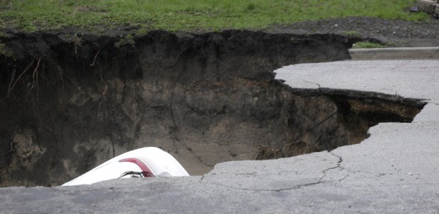
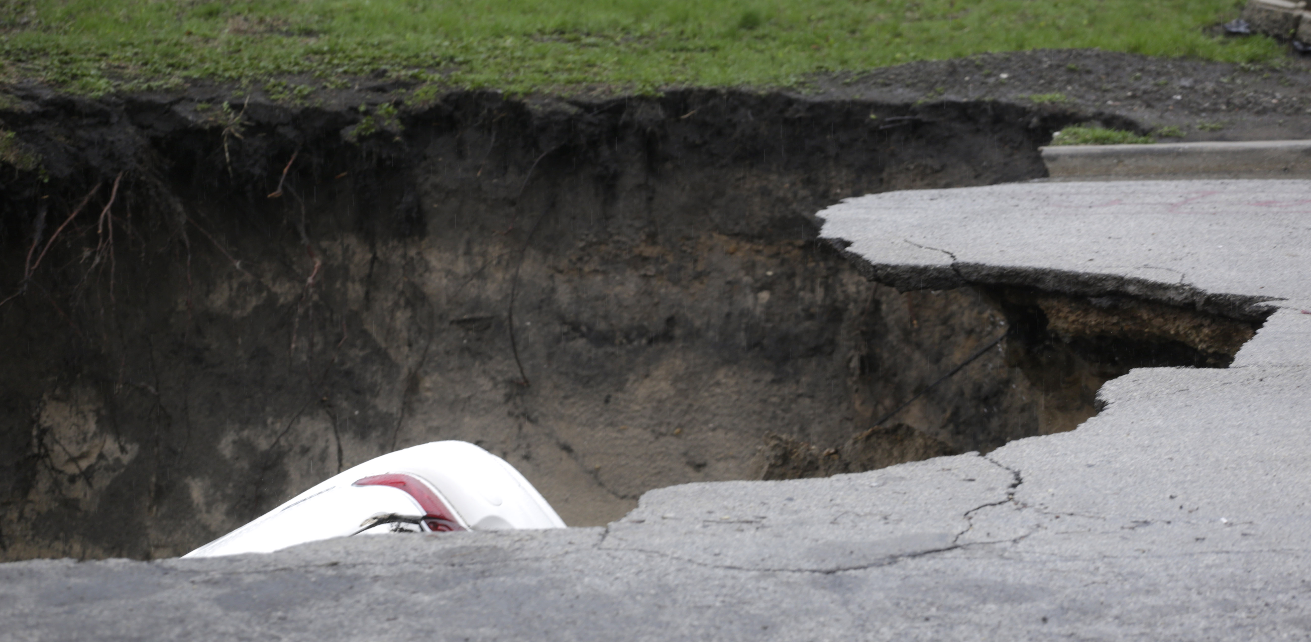
Hundreds of residential properties have been flooded throughout Illinois, and many roadways are reported under water and impassable. City workers are clearing overflowing viaducts and responding to reports of more than 1,200 flooded basements throughout the state. Heavy rain caused a sinkhole in Chicago that swallowed three cars. In central Illinois, a flood-swollen river topped a levee and prompted authorities to evacuate about 700 residents. Road closures were also widespread throughout the city and many of the main routes into and out of the city were submerged under water.
Elsewhere, the Coast Guard has closed the Mississippi River at Vicksburg after barges hit a railroad bridge on Sunday and 30 barges broke free. The section of the Mississippi River was initially closed after more than 114 barges broke free of their moorings.
The floods have also inundated crops and delayed the 2013 corn and soybean planting season, which could shorten the growing season. It is still too early to assess the production risk and chances of potential losses later in the season, AIR said.
AIR will continue to monitor the situation and will provide updates as warranted by events.
Source: AIR Worldwide
AP Photo: M. Spencer Green
 U.S. P/C Industry Books Best Result in a Decade, but Not All Lines Enjoy Success
  Self-Driving Car Firms Must Address Emergency Vehicle Interference
  AI Adoption Continues, But 70% Want More Training: SMB Survey
  Reframing Like a Fox: How Insurance Leaders Can Catch Strategic Drift Before It Compounds
