

















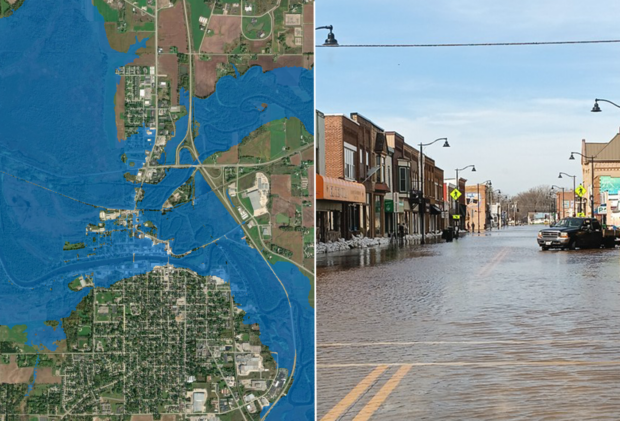
NOAA’s National Weather Service announced that Flood Inundation Mapping (FIM), a tool for predicting river flooding, has expanded from prior coverage of 60% of the country to 100%.
The experimental mapping tool produces estimates of land area covered in water based on model forecast river flows and current conditions that predict where flooding impacts may occur in the following days, the NWS stated.
Forecasters and emergency managers can use it to alert the public on the latest river and stream flooding conditions.
“Inundation maps are a critical tool for assessing the impacts of flooding,” said NOAA Administrator Neil Jacobs, Ph.D. “NOAA prioritized expanding FIM to ensure that nearly every American can access detailed information beyond the expected river crest height.”
FIM puts river and stream flooding on the map at a neighborhood scale, highlighting flooding potential along 3.3 million river miles throughout the continental U.S., U.S. territories and Hawaii, the NWS added.
The mapping tool’s new coverage areas include the southeastern U.S. coast and Florida, the Great Lakes region, New England, the Rocky Mountains, the Dakotas, and western Nebraska.
“FIM has been a game changer when briefing emergency managers, first responders, and communities facing flood risk,” said National Weather Service Director Ken Graham.
The tool was first launched in 2023 covering 10% of the U.S. population and reached 60% in 2025.
This latest expansion covering nearly 100% of U.S. residents does not yet cover northern and western portions of Alaska, Guam, the Northern Mariana Islands and American Samoa.
Expanded maps are publicly available on the National Water Prediction Service website, in several GIS applications available in multiple file types.
Four versions of FIM are available in near-real time for the Lower 48 states and parts of south-central Alaska:
- National Water Model hourly analysis of current conditions
- National Water Model five-day inundation forecast
- NWS River Forecast Center (RFC) five-day inundation forecast
- Static “categorical” FIM (CatFIM) for select NWS River Forecast Points
FIM services for Hawaii, Puerto Rico and the U.S. Virgin Islands include:
- National Water Model hourly analysis of current conditions
- National Water Model 48-hour inundation forecast
- Static “categorical” FIM (CatFIM) for select points at gauged locations
NOAA’s Office of Water Prediction (OWP) is a division of the National Weather Service.
 Edison Utility Shares Drop Due to Willful Misconduct Allegations in Eaton Fire Case
  Delegation Without Abdication: A Division of Labor for Human-AI Decisions in Insurance
  Viewpoint: The ‘Unbundled’ Insurer Emerges in Age of AI as Value Chain Fragments
  Most Americans Think AI Is Developing Too Fast: Poll