


Cotality, a property data and analytics company, estimates that Central Texas flash floods over the July 4 weekend, which claimed the lives of more than 120 people, also caused $1.1 billion in damage to residential buildings.
The risk modeler included the estimate in a report published yesterday, also noting that the damage will likely have only a limited effect on primary insurers and reinsurers.
“Since flood insurance penetration in the region is sparse, most losses will fall on homeowners rather than insurers, which will leave households to shoulder nearly all reconstruction costs and expose a significant insurance gap,” the firm said in a July 21 update on the flood’s consequences.
Cotality estimates that the National Flood Insurance Program (NFIP) may provide as much as $135 million in insurance recoveries to home and business owners but notes a mismatch of expense categories in the report’s damage and insured loss estimates. Specifically, Cotality said that the modeled damage to buildings only includes residential properties and excludes any damage to contents and additional living expenses (ALE). NFIP recoveries include buildings and contents.
Revealing another limitation of the estimates, Cotality said it used precipitation and stream-gauge data to recreate the flood footprint but that uncertainty persists about flood depth and extent, the share of properties with insurance, and the size of their deductibles and limits.
Cotality classified the floods as a 1,000-year rainfall event based on local totals, and stressed that indications like 500-year flood zone boundaries on flood zone maps mark “the limit of data and budget, not a barrier that stops water.”
The report sets forth some of the time-consuming intricacies of flood zone mapping—starting with survey crews who record channel shapes, bridge profiles and levees, and moving to engineers who convert survey measurements into hydraulic models (tracking how water moves).
“‘Low risk’ zones do not mean zero risk,” the firm said, referencing a Cotality Flood Risk Score map of Camp Mystic, a site of more than two dozen fatalities, with some parts labeled extreme risk and others medium and low risk.
Cotality said the July 4 flash floods “proved that extreme storms can push water far beyond mapped zones and damage homes people previously considered safe.”
There was limited insurance penetration in areas outside the 500-year floodplain, where properties still suffered heavy losses, leaving owners with the burden of paying for repairs on their own.
“To close this gap, the region needs clearer communication of residual hazard, stronger community mitigation, and wider uptake of flood coverage that turns a disaster into a more manageable setback,” the report concluded.
Separately, in a July 9 report on the event, Firas Saleh, director of North American Flood Models at Moody’s, said the fact that floods are becoming more frequent and intense “underscores the limitations of relying solely on historical flood levels to assess current and future risk.”
“Risk mitigation remains our frontline defense to help reduce future devastating impacts on communities and economies,” he stated.
Moody’s indicated the size of the flood insurance gap in hard-hit Kerr County. As of May 2025, Moody’s said, there were only 467 NFIP policies, putting the insurance take-up rate at less than 2 percent.
Broadening the analysis, Moody’s said that “over 23 million people in the U.S. live behind levees, relying on these systems for protection against flood risk. These levees safeguard more than $2 trillion in property, including homes, businesses and critical infrastructure. However, the average levee is over 60 years old, meaning many were built before modern engineering standards and designed for a different era, one with less intense rainfall and fewer people in flood-prone areas.”
Stressing the need for mitigation measures in high-risk areas with aging structural defenses, Moody’s referred to the elevation of first floors above base flood elevation, the use of flood-resistant materials, and structural reinforcement to withstand high water velocities.
Focusing on the Texas flood event, the Moody’s report noted that it shattered the impacted area’s “century-old record of 36.60 feet set on July 2, 1932.”
The rapid rise in water levels of the Guadalupe River (over 30 feet in under two hours), along with an explosive increase in river flow (from roughly 10 cubic feet per second to more than 120,000 cubic feet per second), produced hydraulic forces comparable to “those observed in dam break scenarios,” Moody’s said.
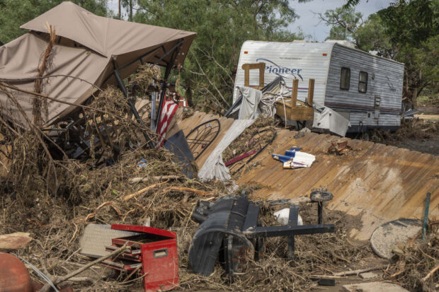
Featured image: Debris from flash flooding is seen at Cedar Stays RV Park in Marble Falls, Texas, Monday, July 7, 2025. (Mikala Compton /Austin American-Statesman via AP)
 AI Pushes Underwriting Beyond Risk Selection to Prevention
  Four Insurers Join Ward’s Annual Top 50 P/C Ranking for 2026
  NY AG Suing 3M, Other Chemical Companies Over PFAS Pollution
  Wendy’s, Chipotle Not Affected by Cyclosporiasis Outbreak