


Hurricane Erin weakened to a Category 3 hurricane on Sunday, with its outer bands lashing the Virgin Islands and Puerto Rico. As forecasters warned of a growing risk of life-threatening surf and rip currents along the U.S. Eastern seaboard during the week, Erin could return to a Category 5 storm.
While Erin’s maximum winds diminished on Sunday, its overall size grew as forecasters issued tropical storm warnings for the Turks and Caicos Islands and the southeast Bahamas. The hurricane’s outer bands pelted parts of Puerto Rico and the Virgin Islands with heavy rains and tropical-storm winds during the day.
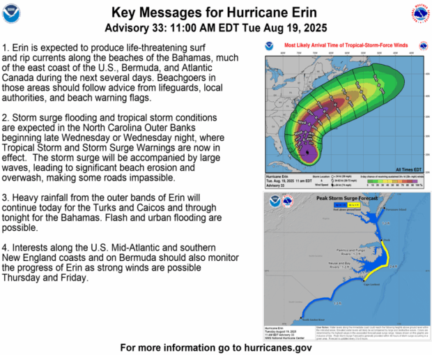
The storm isn’t expected to make U.S. landfall, but by doubling or tripling in size, its impacts threaten the North Carolina Outer Banks, the thin, low stretch of barrier islands off the mainland, that juts far out into the Atlantic, Dare County emergency officials said in declaring a state of emergency.
An evacuation of Hatteras Island was ordered beginning on Monday. Several days of heavy surf, high winds, and waves could wash out parts of North Carolina Highway 12 running along the barrier islands that are a popular vacation destination, the National Weather Service said.
The center of the storm is forecast to stay at least 200 miles (320 kilometers) from the Outer Banks but will also bring rip tides all along the East Coast, officials said.
Bermuda could have similar conditions as Erin is forecast to turn to the north and then northeast, forecasters said.
Erin, the first Atlantic hurricane of 2025, reached an exceedingly dangerous Category 5 status Saturday with maximum winds of 160 mph (260 kph) before weakening. The storm’s maximum sustained winds were 125 mph (205 kph) Sunday afternoon, according to the National Hurricane Center in Miami.
The winds decreased as the storm went through internal changes.
“You’re dealing with a major hurricane. The intensity is fluctuating. It’s a dangerous hurricane in any event,” said Richard Pasch of the National Hurricane Center.
Erin’s center was about 310 miles (500 kilometers) northwest of San Juan, Puerto Rico, and 155 miles (245 kilometers) east-northeast of Grand Turk Island, moving west-northwest at 13 mph (20 kph).
The rain and winds from the outer bands of the storm left about 147,000 customers without power Sunday morning in Puerto Rico, according to Luma Energy, a private company that oversees the transmission and distribution of power on the island. The weather canceled more than 20 flights, officials said.
Swells were also expected to affect portions of the Virgin Islands, Puerto Rico, Hispaniola, and the Turks and Caicos Islands during the next couple of days, forecasters said.
The Coast Guard allowed all ports in Puerto Rico and the U.S. Virgin Islands to reopen on Sunday as winds and rains in the area decreased.
A tropical storm warning means tropical storm conditions are expected somewhere within the warning area, and in this case, within 24 hours, the hurricane center said. Heavy rain is still expected across the Virgin Islands and Puerto Rico, with rainfall of 3 to 6 inches (approximately 7.6 to 15 centimeters), and 8 inches (20 centimeters) in some isolated areas.
Scientists have linked the rapid intensification of hurricanes in the Atlantic to climate change. Global warming is causing the atmosphere to hold more water vapor and is spiking ocean temperatures, with warmer waters providing hurricanes the fuel to unleash more rain and strengthen more quickly.
 Changes in Policy Language, Provisions Suppressing Claim Volume: Report
  AI Pushes Underwriting Beyond Risk Selection to Prevention
  Nearly 463,000 U.S. Kia Owners Warned to Park Outside Over Fire Risks
  Executives on the Move at AXA XL, Chesapeake, AIG, Aon