One of the best-kept secrets about the property/casualty insurance industry is a member-centric organization known as the Geospatial Insurance Consortium, which manages the largest aerial imagery program in the world.
Even with more than a hundred manned planes flying through the clouds over the U.S. alone, the GIC was an under-the-radar organization to Carrier Management until Guest Editor Mike Fitzgerald interviewed Ryan Bank, the consortium’s managing director.
“There is not an insurer on the planet who can afford to do this themselves,” Bank said. Microsoft and Google are the only two companies that were able to do this in the past, he said. “It is hundreds of millions of dollars…It is massive.”
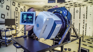
According to Bank, the world’s largest high-resolution aerial imagery program in existence was created by insurers and reinsurers, who pay to keep a fleet of fixed-wing aircraft equipped with special cameras flying over every square inch of the continental U.S., most of Canada, Puerto Rico, all of Western Europe, the UK, Scandinavia, Australia and New Zealand—also recently expanding into Japan as well.
In the accompanying video of the interview, Bank explains how insurers share the cost—and the benefits—of the largest high-resolution aerial imagery program in the world. He also explains why the program uses manned planes rather than satellites to give insurers and reinsurers “drone-level views” of insured properties “at continental scale” in blue skies and gray.
The GIC, conceived by the National Insurance Crime Bureau, is a partnership between NICB and Vexcel, a provider of camera sensors and image processing technology. Vexcel’s team and technology developed Microsoft’s Bing Maps.

After Bank’s conversation with Fitzgerald, the GIC announced a new update to the business model in late October that will make access to imagery captured by the Vexcel equipment even more affordable for some carriers. Marketing Director Kris Wagner said insurers can now opt to participate in a “no-risk transaction program”—a pay-per-use model that lets GIC members elect to pay only for images they use, but never pay more than their assessed market share based on the premium calculation that Bank described. (Under the existing model, the market share-based cost is the member cost, assessed on a quarterly basis.)
While some carriers are innovating fast, others want to start slowly with geospatial information, Wagner noted, giving the example of a carrier that could pay for one staffer to access 1,000 images in the month of July for a specific region under the no-risk program. If the carrier started ramping up to use more imagery across more divisions over time, it would continue to pay per-image costs up until the aggregate total reached the assessed market share cap.
Learn more about becoming a member (7 minutes in).
Fitzgerald, principal analyst, Insurance for CB Insights, served as a guest editor for a series of articles about geospatial information systems in the fourth-quarter edition of Carrier Management magazine and a series of videos on the topic posted on the Carrier Management channel of Insurance Journal TV.
Click the “Download Magazine” button for of CM’s fourth-quarter magazine for a free PDF. To read and share individual articles more easily, become a Carrier Management member to unlock everything.


 Berkshire-owned Utility Urges Oregon Appeals Court to Limit Wildfire Damages
  Preparing for an AI Native Future
  Earnings Wrap: With AI-First Mindset, ‘Sky Is the Limit’ at The Hartford
  How Americans Are Using AI at Work: Gallup Poll