


Forecasters with the National Weather Service raised the likelihood for a below-normal season in their most recent Atlantic hurricane season outlook.
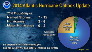
The update predicts a 70 percent chance of a below-normal season, a 25 percent chance of a near-normal season and only a five percent chance of an above-normal season. The probabilities in the initial outlook issued on May 22 were 50 percent, 40 percent and 10 percent, respectively.
The likelihood of El Niño conditions this fall or winter have decreased, the forecasters also said.
Hurricane Conditions
“We are more confident that a below-normal season will occur because atmospheric and oceanic conditions that suppress cyclone formation have developed and will persist through the season.” said Gerry Bell, Ph.D., lead seasonal hurricane forecaster at the National Oceanic and Atmospheric Administration’s (NOAA) Climate Prediction Center, a division of the National Weather Service. “Nonetheless, tropical storms and hurricanes can strike the U.S. during below-normal seasons, as we have already seen this year when Arthur made landfall in North Carolina as a category-2 hurricane. We urge everyone to remain prepared and be on alert throughout the season.”
The primary factors influencing the increased chance of a below-normal season are:
- Overall atmospheric conditions are not favorable for storm development. This includes strong vertical wind shear, a weaker West African monsoon, and the combination of increased atmospheric stability and sinking motion. These conditions mean fewer tropical systems are spawned off the African coast, and those that do form are less likely to become hurricanes. These conditions are stronger than originally predicted in May and are expected to last mid-August through October, the peak months of the hurricane season;
- Overall oceanic conditions are not favorable for storm development. This includes below-average temperatures across the Tropical Atlantic, which are exceptionally cool relative to the remainder of the global Tropics. This cooling is even stronger than models predicted in May and is expected to persist through the hurricane season; and
- El Niño is still likely to develop and to suppress storm development by increasing vertical wind shear, stability and sinking motion in the atmosphere.
- The updated hurricane season outlook, which includes the activity to-date of hurricanes Arthur and Bertha, predicts a 70 percent chance of the following ranges: 7 to 12 named storms (top winds of 39 mph or higher), including 3 to 6 hurricanes (top winds of 74 mph or higher), of which 0 to 2 could become major hurricanes (Category 3, 4, 5; winds of at least 111 mph).
These ranges are centered below the 30-year seasonal averages of 12 named storms, six hurricanes and three major hurricanes. The initial outlook in May predicted 8 to 13 named storms, 3 to 6 hurricanes and 1 to 2 major hurricanes.
The Atlantic hurricane region comprises the North Atlantic Ocean, the Gulf of Mexico and the Caribbean Sea. NOAA’s seasonal hurricane outlook is not a hurricane landfall forecast; it does not predict how many storms will hit land or where a storm will strike. Forecasts for individual storms and their impacts will be provided throughout the season by NOAA’s National Hurricane Center.
The Climate Prediction Center also continued the El Niño watch. Forecasters said that although sea surface temperatures across the central equatorial Pacific have recently returned to near average, this cooling is expected to be temporary. El Niño is now favored to emerge during August-October, and to peak at weak strength during the late fall and early winter. The likelihood of El Niño during August-October has decreased to 55 percent (from 75 percent in May), and its likelihood during the fall and winter has decreased to about 65 percent (from near 80 percent).
*This story originally appeared in our sister publication Insurance Journal.
 What Analysts Are Saying About the 2026 P/C Insurance Market
  Five AI Trends Reshaping Insurance in 2026
  How Americans Are Using AI at Work: Gallup Poll
  Modern Underwriting Technology: Decisive Steps to Successful Implementation