


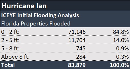
ICEYE, a provider of SAR (synthetic aperture radar) satellite data, revealed on Friday morning that a total of 83,879 Florida properties have been impacted by flooding from Hurricane Ian, based on its initial analysis.
UPDATE: The figures in this article were updated on Oct. 3, 2022. See article: UPDATE: Nearly 360,000 Fla. Properties Flooded By Ian: ICEYE Estimates
While inundation levels were 2 feet or less for 85 percent of the properties, just over 1 percent—over 1,000 properties—had flood levels of 5 feet of more, the ICEYE analysis showed.
ICEYE owns and operates the world’s largest SAR satellite constellation. By combining high-resolution satellite imagery with auxiliary information sources, the company generates unique flood observation data anywhere in the world in near real time, including accurate flood extent footprints and detailed flood depth measurements at the individual building level.
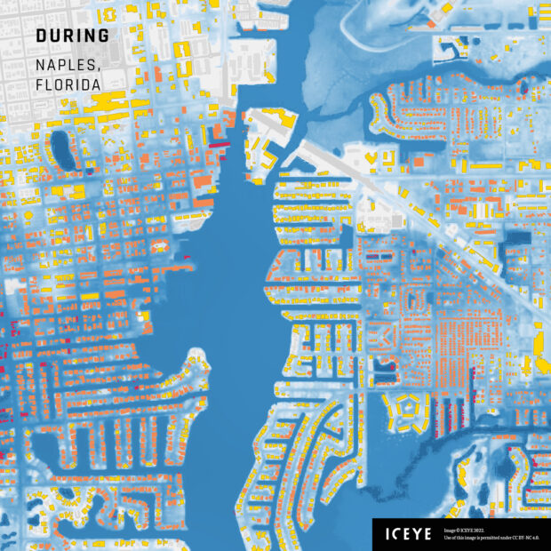
The image of Naples, Fla., accompanying this article, provided by ICEYE, shows the extent of flooding during Hurricane Ian. The colored areas represent flooded buildings, with red areas indicating the greatest amount of flooding (yellow, the least; orange, mid-level flooding).
ICEYE said this initial analysis is focused on areas where there were early indications of heavy flood risk along the western coast of Florida and that the property numbers provided may increase as the company continues to monitor the situation and other areas that have been impacted.
Source: ICEYE
 Executives on the Move at Arch, Allstate, Everest
  Default Speed Limit in Iowa Changes from 55 to 60MPH
  Two Trailers Containing $1.3M in Stolen Copper Wire Recovered in Illinois
  Self-Driving Car Firms Must Address Emergency Vehicle Interference


