I was initially hesitant when asked to share my thoughts on leadership.
A quick Google search will yield thousands of entries—books, ...
 When Mike Fitzgerald, an insurance technology expert, talks about geospatial technology and its applications in property/casualty insurance, he finds it challenging to restrain his enthusiasm about ...
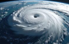
 The title on the cover of the August 2021 edition of Nature magazine—"High and Rising: Satellite images reveal an increasing number of people and places exposed to floods"—gives a sense of what ...
 The prospect of property/casualty insurers and reinsurers adding information from geospatial imagery to their toolkits for underwriting, product development and claims handling isn't an entirely new ...
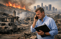
 If there is a bright side to the tumultuous ride that was 2020, it's the surprisingly agile turn property insurers took to move away from traditional reactive approaches toward more proactive ...
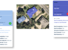
 One of the best-kept secrets about the property/casualty insurance industry is a member-centric organization that manages the largest aerial imagery program in the world. That's right. The world's ...
 Mike Fitzgerald, principal analyst, Insurance for CB Insights, served as a guest editor for this edition of Carrier Management. In addition to conceiving the idea for the featured topic, geospatial ...
Kicking off a Carrier Management Roundtable event on geospatial information systems in mid-October, titled "Seeing Through the Clouds: Satellites in Insurance," panel moderator Mike Fitzgerald, ...
Mike Fitzgerald, principal analyst, Insurance for CB Insights, served as a guest editor for this edition of Carrier Management. In addition to conceiving the idea for the featured topic, geospatial ...
Kicking off a Carrier Management Roundtable event on geospatial information systems in mid-October, titled "Seeing Through the Clouds: Satellites in Insurance," panel moderator Mike Fitzgerald, ...
 Oil spills, port explosions, blockages in the Suez Canal and supply chain risks. These are just some of the events that global space company Skytek has analyzed over the past year for its insurance ...
 The annual ATECH Conference in Aruba is promoted as, "Where Tech, Innovation, and Creativity Meet to Become the Future." At the 2015 conference, two young tech entrepreneurs, Carey Anne Nadeau and ...