













Above-Normal Summer Temperatures Likely Confined to Western and South-Central US
Still Expecting the Weakest Cooling Demand Since 2009
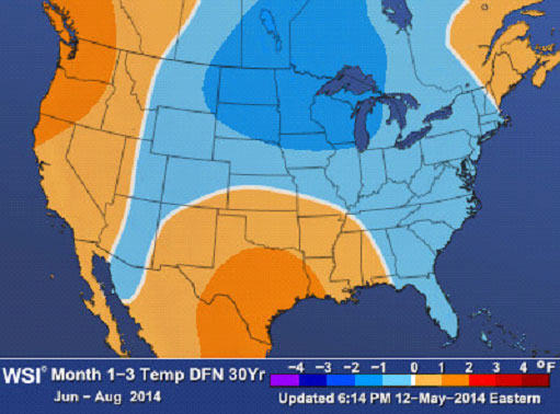
WSI’s team of meteorologists recently released their updated summer forecast for June-August. The summer forecast indicates below-normal temperatures from the southern Rockies northward to the northern Rockies and Plains and then eastward and southward to the mid-Atlantic and Southeast. Warmer-than-normal temperatures will be confined to the western US, southern Plains, and northern New England. The WSI seasonal outlooks reference a standard 30-year normal (1981-2010).
According to WSI Chief Meteorologist Dr. Todd Crawford: “There is little change to our updated summer outlook, as the various statistical/dynamical models we use are in unusually good agreement. It is now clear that an El Nino event is emerging, although the chances of a very strong event (e.g., 1997) now appear relatively small. The forcing from the developing El Nino should result in a higher-than-normal frequency of cool Canadian air masses this summer across much of the northern and eastern US, confining the big heat to the western US and potentially parts of the southern Plains. While we are expecting above-normal temperatures across Texas this summer, the magnitude of the heat will likely be modulated by the amount of rainfall that occurs during the next few weeks. More frequent late spring rains will likely increase the odds of only slightly above-normal aggregate summer temperatures there, while a return to a drier pattern during the next few weeks will increase the odds of more notable heat.”
What does this mean for insurers this season?
The cooler than average weather over the central portion of the United States is part of a pattern that has suppressed the number of tornadoes so far in 2014. In fact, the 18 tornadoes in March marks the 4th lowest number of March tornadoes in the U.S. over the past 50 years. According to meteorologist Ray Hawthorne we’ve had 377 tornadoes year-to-date (through May 20). This is about on pace with last year’s numbers (2013 through 5/20) and last year was a record low for tornado counts in the U.S.
The forecast of cooler-than-average temperatures is part of the reason why WSI forecasters are predicting a 70% chance that this year’s number of tornadoes is lower than the average. However, WSI cautions that it only takes one destructive tornado event in an otherwise quiet season to rack up major insured losses. For example, the May 20, 2013 EF5 tornado in Moore, OK occurred during a tornado season that was one of the least active in more than a decade. It was responsible for an estimated $2B in total damages.
Below is a monthly, region-by-region breakdown of WSI’s forecast for the summer:
In June, WSI sees the monthly breakdown as:
- Northeast* – Warmer than normal New England, cooler than normal mid-Atlantic
- Southeast* – Cooler than normal
- North Central* – Cooler than normal
- South Central* – Warmer than normal
- Northwest* – Warmer than normal
- Southwest* – Warmer than normal
In July, WSI forecasts:
- Northeast – Cooler than normal
- Southeast – Cooler than normal
- North Central – Cooler than normal
- South Central – Warmer than normal
- Northwest – Warmer than normal
- Southwest – Cooler than normal
In August, WSI forecasts:
- Northeast – Cooler than normal, except northern New England
- Southeast – Warmer than normal
- North Central – Cooler than normal
- South Central – Warmer than normal
- Northwest – Warmer than normal
- Southwest – Cooler than normal

 New Florida Property Tax Cut Could Impact Insurance Rates
 Impersonation Top Scam Handled by Allstate
 Allstate’s AI Ecosystem to Include a Personal Agentic Assistant for Customers
 The New Corporate Status Symbol Is How Much AI Access You Have