


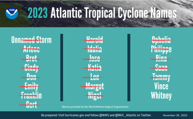
Ending on Nov. 30, the 2023 Atlantic hurricane season saw 20 named storms, ranking fourth for the most-named storms in a year since 1950, the National Oceanic and Atmospheric Administration (NOAA) said.
Seven storms were hurricanes and three intensified to major hurricanes.
An average season has 14 named storms, seven hurricanes and three major hurricanes, according to the U.S. weather agency.
Hurricane Idalia was the only U.S. hurricane to make landfall in 2023. It made landfall as a category 3 hurricane on Aug. 30 near Keaton Beach, Fla., causing storm surge inundation of 7 to 12 feet and widespread rainfall flooding in Florida and throughout the southeast, NOAA reported.
Tropical Storm Ophelia made landfall as a strong tropical storm with 70 mph winds on Emerald Isle, N.C., on Sept. 23 bringing with it heavy rainfall, gusty winds and significant river and storm surge flooding in portions of eastern North Carolina.
Hurricane Lee made landfall as a post-tropical cyclone in Nova Scotia, Canada, on Sept. 16. Swells generated by Lee caused dangerous surf and rip currents along the entire U.S. Atlantic coast, NOAA reported. Strong winds with hurricane‑force gusts from Lee caused extensive power outages in Maine and in parts of Canada.
The storm activity fell within the NOAA Climate Prediction Center’s predicted ranges for named storms and hurricanes in the August updated outlook.
“The Atlantic basin produced the most named storms of any El Nino influenced year in the modern record,” said Matthew Rosencrans, lead hurricane forecaster at NOAA’s Climate Prediction Center, a division of NOAA’s National Weather Service. “The record-warm ocean temperatures in the Atlantic provided a strong counterbalance to the traditional El Nino impacts.”
According to the agency, the eastern Pacific hurricane season was also above normal with 17 named storms, 10 of which resulted in hurricanes; and eight turning into major hurricanes.
From August 16 to 21, Tropical Storm Hilary brought widespread heavy rainfall and flooding to Southern California, with some areas receiving up to 600 percent of their normal August rainfall, NOAA reported.
Hilary resulted in the first ever Tropical Storm Watch and Warning for the Southern California coastline by NOAA’s National Hurricane Center.
Hurricane Otis made landfall near Acapulco, Mexico, on Oct. 25 as a category 5 hurricane with sustained winds of 165 mph. Otis holds the record as the strongest landfalling hurricane in the eastern Pacific after undergoing rapid intensification in which wind speeds increased by 115 mph in 24 hours, the weather agency reported.
The central Pacific basin had a near-normal season with four tropical systems traversing the basin. Hurricane Dora, a category 4 storm, passed south of Hawaii in early August, marking the first major hurricane in the central Pacific basin since 2020, NOAA reported. “The strong gradient between a high pressure system to the north and Dora to the south was a contributing factor to the wind-driven, fast-moving wildfires in Hawaii.”
Hurricane season activity for the eastern Pacific and central Pacific fell within predicted ranges.
“Another active hurricane season comes to a close where hazards from the storms extended well inland from the landfall location,” said NOAA National Hurricane Center Director Michael Brennan, Ph.D. “This underscores the importance of having a plan to stay safe whether you’re at the coast or inland.”
NOAA reported its new Hurricane Analysis and Forecast System helped the National Hurricane Center improve intensity predictions this season.
NOAA’s intensity forecasts showed Hurricane Idalia as a major hurricane impacting the coast of Florida as early as Aug. 28. There were no storm surge fatalities from Idalia, despite storm surge inundation of as much as 12 feet above ground level in some areas, the agency added.
 What to Know About the Widespread Cyclospora Outbreak
  The 24-Hour Window: The Race to Keep Claims Out of Litigation
  Soft P/C Market May Be Shallower Than Previous Cycles: Swiss Re
  Executives on the Move at AXA XL, Chesapeake, AIG, Aon