


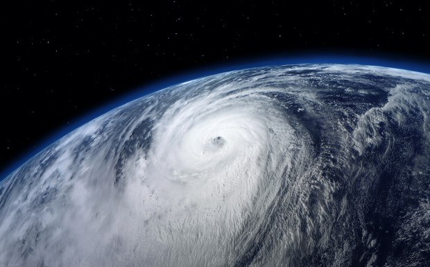
The strongest tropical system the Earth has produced in almost a year is now churning in the Pacific Ocean on a track toward Japan.
Super Typhoon Vongfong’s exact strength may never be known. Yesterday, the best estimate pegged its winds at just over 178 miles (286 kilometers) per hour, according to the U.S. Navy Joint Typhoon Warning Center in Pearl Harbor, Hawaii.
Vongfong, which is forecast to lose strength before reaching Japan, is a Category 5 storm on the five-step Saffir- Simpson wind scale used in the U.S. It’s the strongest system since Super Typhoon Haiyan, which killed more than 6,000 people in the Philippines last November with winds estimated at the time at 190 to 195 mph.
The lack of clarity for Vongfong, Haiyan and Cyclone Hudhud, now off the coast of India, comes from not having anyone inside the storm measuring its power. That’s a regular procedure for storms in the Atlantic and off the Pacific coast of Mexico.
The U.S. is the only country that regularly flies into tropical cyclones, the name given to the class of storms that include hurricanes and typhoons, said Dennis Feltgen, spokesman for the National Hurricane Center in Miami.
The information these flights gather gives forecasters in the Atlantic and eastern Pacific a much clearer picture of a storm’s power and temperament than anything else in the world, said Jeff Masters, co-founder of Weather Underground in Ann Arbor, Michigan.
Truth Inside
“You get the truth from actually being in the storm,” said Masters, who flew into storms himself while working for the National Oceanic and Atmospheric Administration. “You find a lot of things that go on that you don’t see on satellites.”
The U.S. Hurricane Hunters, as the reconnaissance flights are called, were born in 1943 when two Army Air Corps pilots dared each other to fly into a storm, according to the U.S. Air Force Reserve Command. In July of that year, Major Joe Duckworth flew a single-engine trainer through the eye of a hurricane.
While a lot of good information can be gleaned from satellites, the gap between the estimates and what the storm is actually doing can be significant. Earlier this year, Typhoon Rammasun — which went ashore in China, killed at least 62 and destroyed thousands of homes — was stronger than projections, Masters said.
Satellites ‘Off’
“Satellites are off a lot on the most intense cyclones,” he said.
Masters, who has written about his experience flying into Hurricane Hugo in 1989, said drones may be able to eventually close the gap between what is known in the Atlantic and unknown in the Pacific. All it will take is money.
Fortunately for Japan, Vongfong won’t be able to hold onto its power as it nears that nation. The Joint Typhoon Warning Center forecast calls for its winds to drop to about 86 mph, Category 1 level, by the time it gets close to Kyushu in about three days.
Masters said there is also a chance it will miss Japan completely and sweep out into the central Pacific.
India, most likely, won’t be that lucky. Hudhud could reach the power of a Category 3 storm with winds of almost 121 mph as it nears the coast close to Visakhapatnam in about three days, the Navy estimates.
Masters said the storm will track across warm water without much wind shear to tear at its structure, so there’s nothing to keep it from getting and staying strong as it nears land. For the people in Hudhud’s path, it would help to be able to take a closer look.
 NY AG Suing 3M, Other Chemical Companies Over PFAS Pollution
  AI Adoption Continues, But 70% Want More Training: SMB Survey
  Default Speed Limit in Iowa Changes from 55 to 60MPH
  Ranking: Who Are the Insurance Industry’s AI Talent, Maturity Leaders?


