


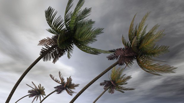
A pair of storms bearing down on Hawaii threatens to bring rain, flash floods and mudslides to the island state during one of its peak months for tourism.
Hurricane Iselle, with top winds of 90 miles (145 kilometers) per hour, was 405 miles east-southeast of Hilo, Hawaii, while Hurricane Julio, which strengthened to Category 2 on the five-step Saffir-Simpson scale, had winds of 100 mph and was 1,340 miles from the city, the U.S. Central Pacific Hurricane Center and the National Hurricane Center said at 5 a.m. in New York. Iselle would be the first hurricane to hit Hawaii since 1992, according to Commodity Weather Group LLC.
“Iselle is on the collision course with Hawaii and is slated to cross over the Big Island in about 24 hours,” David Streit, a meteorologist at CWG in Bethesda, Maryland, said by e- mail today. “The storm will produce locally heavy rains and flash flooding,” before clearing out in two days, he said.
Starwood Hotels & Resorts Worldwide Inc. is taking steps including shutting off gas lines to outdoor tiki torches and moving food-and-beverage service indoors at its Hawaii properties, Stephanie Dowling, a spokeswoman for the company, said in an e-mail. It is also waiving cancellation fees for guests whose travel plans are affected by the storms.
Tourism in Hawaii tends to peak in June, July and August, when schools are out for vacation, Ken Rewick, vice president of flight operations for Hawaiian Airlines Inc., said by telephone from the company’s headquarters in Honolulu. Iniki was the last hurricane to hit Hawaii, striking the island of Kauai in 1992, according to Streit of CWG.
Historic Impact
A hurricane warning was issued for the Big Island of Hawaii and its surrounding waters, according to the local National Weather Service office. Hurricane conditions are expected to develop on the Big Island today, it said.
“To have two impact the island in such a short amount of time, I don’t see anything in recent history where that has happened,” said Carl Erickson, a meteorologist with AccuWeather Inc. in State College, Pennsylvania.
Iselle is forecast to hit the Big Island late today, while Julio may track just north of the island chain early next week. Iselle may still be at hurricane strength as it nears the Big Island, the Central Pacific center said. Julio is on a “more northerly track” and should only produce high surf with winds of 25 to 35 knots on Aug. 10, according to CWG.
Regardless of whether Iselle reaches the Big Island as a tropical storm or minimal hurricane, its impact will be similar, the center said in a forecast analysis yesterday.
Tourism Cost
Airlines and hotels in the state started waiving cancellation and change fees, the Hawaii Tourism Authority said in an e-mailed advisory yesterday. The state Division of Forestry and Wildlife closed its managed lands, including wildlife sanctuaries, reserves and hiking trails on the Big Island and Maui, the statement shows.
Flash flood watches were posted for all the islands through the weekend, according to the weather service.
Hawaiian Airlines will probably delay flights rather than cancel them, Rewick said. Storms tend to “come in clusters but this close is not typical,” he said. “Julio seems to be taking a more northerly track, which for the islands is helpful because it gets up into the higher, cooler water and saps the energy out of them.”
Oil Refineries
Hawaii is home to two oil refineries, run by Chevron Corp. and Par Petroleum Corp. on the island of Oahu. Chevron’s 54,000 barrel-a-day plant continues to supply the market, Braden Reddall, a spokesman for the San Ramon, California-based company, said by e-mail yesterday from the refinery.
Iselle, the stronger of the two systems, will probably pass directly over the Big Island, bringing as much as 8 inches (20 centimeters) of rain there and to Maui, AccuWeather’s Erickson said. Maui should see tropical storm force winds of 35 knots gusting to 50 knots, CWG’s Streit said.
“That could lead to flooding, mudslides and some roadways may even get washed out,” he said.
After the storm passes, there will be a bit of clearing before Julio tracks just to the north, he said. Julio may bring heavy precipitation to the islands even if it misses a direct strike.
There’s a possibility Julio’s track could change in the next few days, bringing it closer to the islands, Erickson said. The path of both storms is being controlled by a high pressure system to the north ofHawaii, and if that were to strengthen, Julio could get nearer.
“Global model fields are now indicating that a break in the ridge currently to the north of Hawaii may fill in just enough over the next few days to keep Julio from turning northwestward,” the National Hurricane Center said in a forecast discussion on its website.
Hurricane Hits
Storms coming from the east are rare for Hawaii because sea surface temperatures on that side are cool and rob systems of their strength, Erickson said. It’s more common for a powerful tropical system to come up from the south, where the ocean is warmer.
Only two hurricanes, tropical systems with winds of at least 74 mph, have made direct strikes onHawaii since 1949, said Jeff Masters, founder of Weather Underground, in his blog.
One of those was Hurricane Iniki, which struck as a Category 4 storm, killing six and causing $2 billion in damage in September 1992, Masters wrote.
To contact the reporters on this story: Brian K. Sullivan in Boston at bsullivan10@bloomberg.net; Lynn Doan in San Francisco at ldoan6@bloomberg.net; Isis Almeida in London at ialmeida3@bloomberg.net To contact the editors responsible for this story: David Marino at dmarino4@bloomberg.net Lars Paulsson, Dan Weeks
 Two Trailers Containing $1.3M in Stolen Copper Wire Recovered in Illinois
  AI Adoption Continues, But 70% Want More Training: SMB Survey
  Soft P/C Market May Be Shallower Than Previous Cycles: Swiss Re
  Leadership Change at Vantage: Former Arch Execs Grandisson, Gansberg to be Chair, CEO


