


Wildfires continued to be costly for many insurers, resulting in billions of dollars in losses, and possibly growing. According to data from the National Interagency Fire Center, in 2022 there were roughly 69,000 fires. Nationwide fires burned more than 7.5 million acres, with activity varying from state to state.
Rising temperatures, extreme droughts, and altered precipitation patterns extend wildfire “seasons” to virtually year-round.
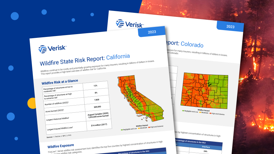
New Wildfire Risk Reports from Verisk demonstrate updated views of wildfire risk across 13 western states: AZ, CA, CO, ID, MT, NV, NM, OK, OR, TX, UT, WA, and WY.
Wildfire exposure by county
Using FireLine®, a wildfire risk assessment tool, Verisk estimates around 7% of properties are at high to extreme risk for wildfires across the 13 states. Nearly 3.3 million U.S. properties are at high to extreme risk for wildfire, with over 1.7 million of these addresses in California.
States with the highest risk concentration include Montana and Idaho at 12% and 11%, respectively. California, a key state for regulatory reform, has nearly 8% of properties at high to extreme risk.
The Verisk Wildfire model for the U.S. explicitly accounts for fire branding/spotting, the primary mode of fire spread into the wildland-urban interface (WUI) and through urban areas.
The percentage of structures in the WUI are estimated by leveraging Verisk’s Industry Exposure Database and data from the U.S. Geological Survey. Looking across the 13 coverage states, Verisk estimates that 23% of structures are located in the Intermix, and 33% of structures are located in the interface.
Factoring in complimentary views of risk
Continued development within high-risk areas—WUI and intermix WUI areas—creates a high potential for increasing loss exposure. Using permit data, Verisk is able to identify counties with increasing, decreasing, or stabilizing new construction activity.
Additionally, at the property and community levels, efforts to reduce risk through property maintenance and vegetation management can make a given property less susceptible to loss or damage from wildfire. This concept is also known as mitigation.
Verisk has been working with the National Fire Protection Association (NFPA®), leveraging robust data from its Firewise USA® recognition program, which analyzes thousands of communities across various states engaging in wildfire mitigation efforts. More than 95% of communities recognized as Firewise USA maintain their active status over multiple years.
What happens after – a focus on claims and reconstruction
As natural catastrophes become more frequent, severe, and widespread, granular property data and reliable reconstruction cost estimates (RCEs) can help keep policyholders appropriately protected and supported in a time of loss.
Using 360Value®, average reconstruction costs for residential and commercial structures across the 13 states increased 4% and 6%, respectively, from September 2022 to September 2023. Lengthening build times creates additional pressures as inflation increases over the course of construction.
Read Verisk’s Wildfire Risk Reports, which provide a high-level overview of wildfire risk for the 13 western states impacted by the peril.
Dr. Arindam Samanta is director of product management at Verisk.
John Britt is a product executive for business intelligence in Verisk’s Property Estimating Solutions.
Dr. Jeff Amthor is an assistant vice president in Verisk’s Extreme Event Solutions.
 Executives on the Move at AXA XL, Chesapeake, AIG, Aon
  Sompo Acquiring Workers Comp Writer Service Insurance Companies
  Florida Supreme Court Ruling Could Mean New Pressure to Settle High-Dollar Lawsuits
  Prosecutors Can Review Tiger Woods’ Med Records in Florida DUI Case: Judge