


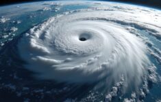


Catastrophe risk modeler AIR Worldwide has updated its U.S. hurricane model with a hydrodynamic storm surge module that integrates storm parameters with high-resolution elevation data to simulate location-specific storm surge inundation depth and extent.
AIR said the storm surge module incorporates the 30-meter National Elevation Dataset (NED) developed by the USGS and leverages a customized variation of NOAA’s Sea, Lake and Overland Surges from Hurricanes (SLOSH) model. The storm surge module incorporates regional and seasonal data on tide heights and contains up-to-date data on levees, seawalls, floodgates, pump systems, and other mitigating structures and equipment—including the most up-to-date levee information available for New Orleans, according to a statement from AIR.
Other model updates include the most recent North Atlantic hurricane database (HURDAT2) from NOAA, the latest reanalysis data from 1930-1945 and the 2011 release of the USGS National Land Cover Database (NLCD 2011). AIR said the update also incorporates the latest data on the impact of square footage on wind losses for large, high-value homes as well as the vulnerability of manufactured homes.
“Our view of hurricane risk in the United States has been refined by new hazard data, enhanced modeling of storm surge and flood defenses, and an improved understanding of building vulnerability,” said Dr. Tim Doggett, assistant vice president and senior principal scientist at AIR Worldwide. “The highly granular estimates produced by the model can help insurers better understand the risk from hurricane wind and storm surge, supporting improved risk selection, portfolio management and risk transfer decisions.”
The AIR Hurricane Model for the United States is available in the Touchstone 3.0 and CATRADER 17 catastrophe risk management systems.
 20,000 AI Users at Travelers Prep for Innovation 2.0; Claims Call Centers Cut
  How Americans Are Using AI at Work: Gallup Poll
  Insurance Groundhogs Warming Up to Market Changes
  Retired NASCAR Driver Greg Biffle Wasn’t Piloting Plane Before Deadly Crash


